1930s Maps of Scottsboro, Alabama
Explore 6 historic maps of Scottsboro from the 1930s. These maps offer a rare glimpse into what life looked like during the 1930s — showing old roads, neighborhoods, homes, and landmarks that have changed or disappeared over time.
Whether you're researching your family's past, planning a metal detecting trip, or studying how Scottsboro's landscape evolved across the 1930s, these high-resolution maps are a powerful tool for exploring the history of this region.
- Focus on a specific era: All maps on this page are from the 1930s, giving you a focused view of this time period.
- See what’s changed: Compare century-old streets, trails, and buildings to today's modern landscape using overlays and satellite layers.
- Research with precision: Use these maps for genealogy, historical research, land use analysis, or educational projects.
- View, download, or print: Maps are fully viewable online in high resolution, and can be downloaded or printed for your own records.
Start exploring Scottsboro's history through authentic maps from the 1930s. This is your window into the past.
Scottsboro, AL maps
(6)- 1936 Map of Scottsboro
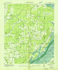
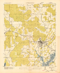 1936 Scottsboro1936 Print · USGSJackson County is captured during the mid-1930s TVA transformations, showing the valley just before the reservoir waters rose. Trace family roots at Cedar Hill Cem, Larkinsville, or the curiously named House of Happiness Sch.
 - 1936 Map of Langston
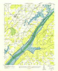
 1936 Langston1936 Print · USGSJackson and Marshall counties are captured during the 1930s as the Tennessee Valley Authority prepared to flood the valley. Local historians can trace the original landscape around Langston before the reservoir arrived, including Larkins Ferry, Kelley Cem, and St Joseph Sch.
 - 1936 Map of Dutton
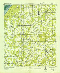 1936 Dutton1936 Print · USGSSand Mountain and the Tennessee River valley appear here in the mid-thirties just as the landscape began to change. Trace the old community footprints of Dutton and Macedonia or locate family landmarks like Happy Hill Ch and Patterson Sch.
 - 1936 Map of Lim Rock
 1936 Lim Rock1936 Print · USGSJackson County in the mid-1930s shows a landscape of rail-side towns and mountain hollows as the new reservoir begins to take shape. Researchers can trace ancestral roots through sites like Lim Rock Sch, Wininger, and the Bethlehem Ch.
 - 1936 Map of Hollywood
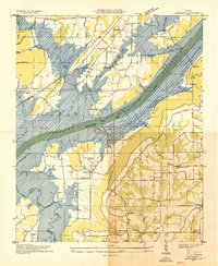
 1936 Hollywood1936 Print · USGSJackson County is captured during the mid-thirties as the Tennessee Valley Authority prepared for the flooding of the Guntersville Reservoir. You can trace the old paths of the Lee Highway, locate the Wheeler Mine, or find family names at Phillip Cem and Bellefonte Cem.
 - 1936 Map of Swearengin
 1936 Swearengin1936 Print · USGSMarshall and Jackson counties appear here just as the Tennessee Valley Authority began transforming the region in the mid-1930s. Genealogists and historians can trace family locations through sites like Old Barclay Mill, the State Prison Camp C, and the Zions Rest Cem before the reservoir waters rose.
End of results
Showing maps 1-6 of 6
Top cities near Scottsboro
- Guntersville historical maps
- Rainsville historical maps
- Stevenson historical maps
- Sylvania historical maps
- Grant historical maps
- Fyffe historical maps
See more
Top neighborhoods of Scottsboro
- Lakeview Shores historical maps
- Sam Gant Subdivision historical maps
- Webb Addition historical maps
- Larkinsville historical maps
- Roseberry historical maps
- Bradford Subdivision historical maps
See more
Frequently asked questions
- What are the different types of historical maps available for Scottsboro?
- What is the oldest map of Scottsboro?
- Where can I purchase historical maps of Scottsboro for my home or office?
- Where can I download high-res historical maps of Scottsboro?
- Are there historical topographic maps available for Scottsboro?
- Is there historical aerial imagery available for Scottsboro?
- Where are historical maps of Scottsboro sourced from?