1940s Maps of Scottsboro, Alabama
Explore 6 historic maps of Scottsboro from the 1940s. These maps offer a rare glimpse into what life looked like during the 1940s — showing old roads, neighborhoods, homes, and landmarks that have changed or disappeared over time.
Whether you're researching your family's past, planning a metal detecting trip, or studying how Scottsboro's landscape evolved across the 1940s, these high-resolution maps are a powerful tool for exploring the history of this region.
- Focus on a specific era: All maps on this page are from the 1940s, giving you a focused view of this time period.
- See what’s changed: Compare century-old streets, trails, and buildings to today's modern landscape using overlays and satellite layers.
- Research with precision: Use these maps for genealogy, historical research, land use analysis, or educational projects.
- View, download, or print: Maps are fully viewable online in high resolution, and can be downloaded or printed for your own records.
Start exploring Scottsboro's history through authentic maps from the 1940s. This is your window into the past.
Scottsboro, AL maps
(6)- 1947 Map of Langston, 1972 Print
 1947 Langston1972 Print · USGSNortheast Alabama during the mid-century transition shows a landscape defined by the Tennessee River and the rising waters of Guntersville Lake. Genealogists and local historians can trace family locations near Langston, explore several churches like Hollis Memorial Church, and find family burial grounds including Finney Cem and Kelly Cem.2 unique versions available
 - 1947 Map of Dutton, 1972 Print
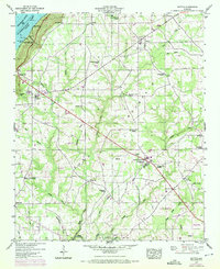 1947 Dutton1972 Print · USGSSand Mountain settlements and the Guntersville Lake shoreline appear in this mid-century survey as the Tennessee Valley transformed. Trace family roots at Chaney Chapel Cem or locate old community hubs like Gossett Gap and Hancock Crossroads.2 unique versions available
 - 1947 Map of Scottsboro, 1972 Print
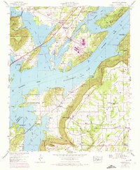
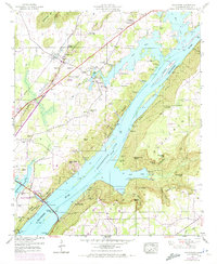
 1947 Scottsboro1972 Print · USGSScottsboro and the surrounding Jackson County coves are captured here during a period of mid-century growth and agricultural transition. Researchers can locate family landmarks like Shelton Cem, rural churches such as New Home Ch, and the grounds of the Tri-Counties Tuberculosis Sanatorium.2 unique versions available
 - 1947 Map of Swearengin, 1972 Print
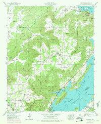 1947 Swearengin1972 Print · USGSNortheast Alabama's river-cut plateau comes into focus here just after the mid-century, showing the rugged intersection of Guntersville Lake and the mountain coves. Genealogists and hikers can trace the rural landscape of Swearengin, from the depths of Cathedral Caverns to Zions Rest Cem.2 unique versions available
 - 1947 Map of Hollywood, 1972 Print
 1947 Hollywood1972 Print · USGSJackson County is shown during a period of transition as the Tennessee River valley matured around Guntersville Lake. Researchers can trace family history through sites like Hollywood School and over a dozen family cemeteries including Finnell Cem and Hudgins Cem.4 unique versions available
 - 1947 Map of Lim Rock, 1974 Print
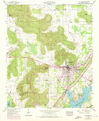
 1947 Lim Rock1974 Print · USGSJackson County rural life is captured here in the mid-twentieth century, centered on the valley floor between the plateau and the Tennessee River backwaters. Genealogists can locate family landmarks like Peters Cove Cem, Letcher Ch, and the old Lim Rock School.2 unique versions available
End of results
Showing maps 1-6 of 6
Top cities near Scottsboro
- Guntersville historical maps
- Rainsville historical maps
- Stevenson historical maps
- Sylvania historical maps
- Grant historical maps
- Fyffe historical maps
See more
Top neighborhoods of Scottsboro
- Lakeview Shores historical maps
- Sam Gant Subdivision historical maps
- Webb Addition historical maps
- Larkinsville historical maps
- Roseberry historical maps
- Bradford Subdivision historical maps
See more
Frequently asked questions
- What are the different types of historical maps available for Scottsboro?
- What is the oldest map of Scottsboro?
- Where can I purchase historical maps of Scottsboro for my home or office?
- Where can I download high-res historical maps of Scottsboro?
- Are there historical topographic maps available for Scottsboro?
- Is there historical aerial imagery available for Scottsboro?
- Where are historical maps of Scottsboro sourced from?