1900s (20th Century) Maps of Skyline, Alabama
Explore 11 historic maps of Skyline from the 1900s (20th Century). These maps offer a rare glimpse into what life looked like during the 1900s — showing old roads, neighborhoods, homes, and landmarks that have changed or disappeared over time.
Whether you're researching your family's past, planning a metal detecting trip, or studying how Skyline's landscape evolved across the 1900s, these high-resolution maps are a powerful tool for exploring the history of this region.
- Focus on a specific era: All maps on this page are from the 1900s, giving you a focused view of this time period.
- See what’s changed: Compare century-old streets, trails, and buildings to today's modern landscape using overlays and satellite layers.
- Research with precision: Use these maps for genealogy, historical research, land use analysis, or educational projects.
- View, download, or print: Maps are fully viewable online in high resolution, and can be downloaded or printed for your own records.
Start exploring Skyline's history through authentic maps from the 1900s. This is your window into the past.
Skyline, AL maps
(11)- 1936 Map of Mud Creek
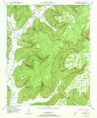
 1936 Mud Creek1936 Print · USGSJackson County in the mid-1930s shows a landscape of mountain plateaus and creek-side settlements. Genealogists can locate family landmarks like Bynum Cem, Fairfield Sch, and the community of Tupelo.
 - 1936 Map of Princeton
 1936 Princeton1936 Print · USGSThe Paint Rock River valley in the mid-1930s was a network of cove-based farmsteads and upland mines. Genealogy researchers can locate family sites near Princeton, the Camp Ground Ch, and coal operations at Jacobs Mine.
 - 1948 Map of Princeton, 1973 Print
 1948 Princeton1973 Print · USGSThe Paint Rock River valley in the late 1940s reveals a landscape of isolated farming communities and family-named hollows. Trace your ancestry through local landmarks like Princeton, the Guess Creek Church, and family cemeteries including Latham Cem and Clay Cem.3 unique versions available
 - 1948 Map of Mud Creek, 1975 Print
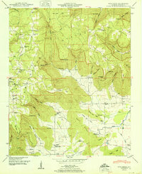
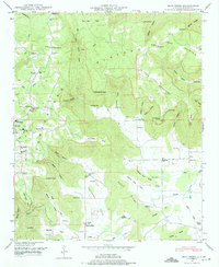 1948 Mud Creek1975 Print · USGSJackson County in the late 1940s reveals a rural landscape defined by the Cumberland Plateau and its deeply carved hollows. Genealogists can trace family names through numerous landmarks like Holland Chapel, Skyline Cem, and the Tupelo settlement.5 unique versions available
 - 1951 Map of Princeton
 1951 Princeton1951 Print · USGSJackson County valley life in the early fifties centers on the river forks and mountain coves. Genealogists can trace family names at Latham Cem and Prince Cem or locate the rural congregations of Camp Ground Church and Guess Creek Church.2 unique versions available
 - 1951 Map of Mud Creek
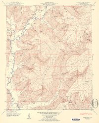
 1951 Mud Creek1951 Print · USGSJackson County, Alabama, is captured here in the early 1950s, showing a rugged landscape of ridges and coves before modern development. Family historians can trace ancestral roots through dozens of local landmarks like Holland Chapel, Kyles Sch No 1, and the Maynard Cove settlement.2 unique versions available
 - 1956 Map of Gadsden, 1966 Print
 1956 Gadsden1966 Print · USGSNorth Alabama in the mid-1950s shows a region transformed by river engineering and federal industry. Genealogists and local historians can trace the development of the Tennessee Valley through the growth of Huntsville, the sprawling Redstone Arsenal, and the expansive Guntersville Lake.3 unique versions available
 - 1958 Map of Gadsden
 1958 Gadsden1958 Print · USGSNorth Alabama comes alive in the late 1950s as the Tennessee Valley Authority’s massive river projects and the rise of the space industry reshaped the landscape. Researchers can trace the mid-century footprints of Huntsville, Redstone Arsenal, and the riverside rail networks of the Southern railroad.
 - 1960 Map of Gadsden
 1960 Gadsden1960 Print · USGSNorthern Alabama in the mid-1950s is defined by the mighty Tennessee River and its massive reservoirs. Trace the development of Huntsville and Redstone Arsenal or explore the vast William B Bankhead National Forest.2 unique versions available
 - 1963 Map of Gadsden
 1963 Gadsden1963 Print · USGSNorthern Alabama underwent a dramatic mid-century transformation as the Tennessee Valley became a hub for defense and industry. Researchers can trace the development of the Redstone Arsenal, the route of the Natchez Trace Parkway, and long-standing rail lines like the Southern Railway.
 - 1984 Map of Huntsville, 1986 Print
 1984 Huntsville1986 Print · USGSNorthern Alabama and the Tennessee borderlands are captured in the mid-eighties as Huntsville and the Redstone Arsenal expand. Researchers can trace rural landmarks from Woodlin Mill to the Cumberland Plateau and old rail lines like the Southern.3 unique versions available
End of results
Showing maps 1-11 of 11
Top cities near Skyline
- Scottsboro historical maps
- Hollywood historical maps
- Gurley historical maps
- Section historical maps
- Woodville historical maps
- Hytop historical maps
See more
Top neighborhoods of Skyline
Frequently asked questions
- What are the different types of historical maps available for Skyline?
- What is the oldest map of Skyline?
- Where can I purchase historical maps of Skyline for my home or office?
- Where can I download high-res historical maps of Skyline?
- Are there historical topographic maps available for Skyline?
- Is there historical aerial imagery available for Skyline?
- Where are historical maps of Skyline sourced from?