1900s (20th Century) Maps of Woodville, Alabama
Explore 12 historic maps of Woodville from the 1900s (20th Century). These maps offer a rare glimpse into what life looked like during the 1900s — showing old roads, neighborhoods, homes, and landmarks that have changed or disappeared over time.
Whether you're researching your family's past, planning a metal detecting trip, or studying how Woodville's landscape evolved across the 1900s, these high-resolution maps are a powerful tool for exploring the history of this region.
- Focus on a specific era: All maps on this page are from the 1900s, giving you a focused view of this time period.
- See what’s changed: Compare century-old streets, trails, and buildings to today's modern landscape using overlays and satellite layers.
- Research with precision: Use these maps for genealogy, historical research, land use analysis, or educational projects.
- View, download, or print: Maps are fully viewable online in high resolution, and can be downloaded or printed for your own records.
Start exploring Woodville's history through authentic maps from the 1900s. This is your window into the past.
Woodville, AL maps
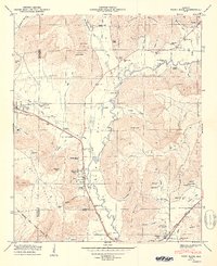
(12)- 1936 Map of Grant
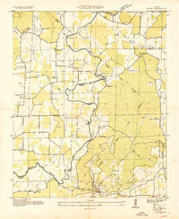 1936 Grant1936 Print · USGSAs the mid-1930s brought the Tennessee Valley Authority to Marshall County, this area balanced its mountain heritage with new river developments. Genealogists and researchers can trace family landmarks like Butlers Mill, Fishtrap Ford, and the DAR Sch.
 - 1936 Map of Paint Rock
 1936 Paint Rock1936 Print · USGSPaint Rock and the surrounding Jackson County river valley appear in 1936 as a landscape of small railway towns and mountain ridges. Genealogists and historians can trace community roots through landmarks like Rosenwald Sch, Walkers Mill, and Union Cem.
 - 1947 Map of Grant, 1970 Print
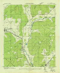
 1947 Grant1970 Print · USGSNortheastern Alabama’s river valleys and mountain ridges are captured here just after the war, showing the rural landscape where three counties meet. Genealogists can trace family landmarks like Keel Cem, Butler Mill, and the many river crossings including Hellum Ford.4 unique versions available
 - 1948 Map of Paint Rock, 1966 Print
 1948 Paint Rock1966 Print · USGSThe Paint Rock River valley in the late 1940s reveals a network of small Jackson County communities and riverside crossings. Genealogists and historians can locate numerous family burial sites like Latham Cem and trace the historic Southern RR past the Conyers-Rosenwald School.5 unique versions available
 - 1950 Map of Paint Rock
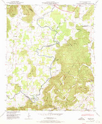
 1950 Paint Rock1950 Print · USGSThe Paint Rock River valley in the late 1940s reveals a corridor of rail-and-road activity connecting Jackson and Madison counties. Genealogists can trace family names across Rousseau Cem, the Conyers-Rosenwald School, and the river crossing at Walker Mill Ford.2 unique versions available
 - 1950 Map of Grant
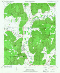
 1950 Grant1950 Print · USGSNortheast Alabama at mid-century shows a landscape of river-valley farms and steep ridges at the intersection of three counties. Trace old river crossings at Helium Ford and Fishtrap Ford, or locate family landmarks like Poplar Ridge, Butler Mill, and the D A R Sch.2 unique versions available
 - 1956 Map of Gadsden, 1966 Print
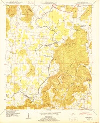
 1956 Gadsden1966 Print · USGSNorth Alabama in the mid-1950s shows a region transformed by river engineering and federal industry. Genealogists and local historians can trace the development of the Tennessee Valley through the growth of Huntsville, the sprawling Redstone Arsenal, and the expansive Guntersville Lake.3 unique versions available
 - 1958 Map of Gadsden
 1958 Gadsden1958 Print · USGSNorth Alabama comes alive in the late 1950s as the Tennessee Valley Authority’s massive river projects and the rise of the space industry reshaped the landscape. Researchers can trace the mid-century footprints of Huntsville, Redstone Arsenal, and the riverside rail networks of the Southern railroad.
 - 1960 Map of Gadsden
 1960 Gadsden1960 Print · USGSNorthern Alabama in the mid-1950s is defined by the mighty Tennessee River and its massive reservoirs. Trace the development of Huntsville and Redstone Arsenal or explore the vast William B Bankhead National Forest.2 unique versions available
 - 1963 Map of Gadsden
 1963 Gadsden1963 Print · USGSNorthern Alabama underwent a dramatic mid-century transformation as the Tennessee Valley became a hub for defense and industry. Researchers can trace the development of the Redstone Arsenal, the route of the Natchez Trace Parkway, and long-standing rail lines like the Southern Railway.
 - 1984 Map of Huntsville, 1986 Print
 1984 Huntsville1986 Print · USGSNorthern Alabama and the Tennessee borderlands are captured in the mid-eighties as Huntsville and the Redstone Arsenal expand. Researchers can trace rural landmarks from Woodlin Mill to the Cumberland Plateau and old rail lines like the Southern.3 unique versions available
 - 1997 Map of Paint Rock, 2001 Print
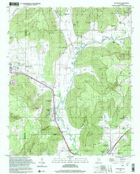 1997 Paint Rock2001 Print · USGSThe Paint Rock River valley in the late twentieth century remains a landscape of deep hollows and family-named ridges. Genealogists can trace rural roots through a dozen local burial grounds including Rousseau Cem and the historic Conyers-Rosenwald School.
End of results
Showing maps 1-12 of 12
Top cities near Woodville
- Huntsville historical maps
- Scottsboro historical maps
- Guntersville historical maps
- New Hope historical maps
- Owens Cross Roads historical maps
- Grant historical maps
See more
Frequently asked questions
- What are the different types of historical maps available for Woodville?
- What is the oldest map of Woodville?
- Where can I purchase historical maps of Woodville for my home or office?
- Where can I download high-res historical maps of Woodville?
- Are there historical topographic maps available for Woodville?
- Is there historical aerial imagery available for Woodville?
- Where are historical maps of Woodville sourced from?