1940s Maps of Woodville, Alabama
Explore 2 historic maps of Woodville from the 1940s. These maps offer a rare glimpse into what life looked like during the 1940s — showing old roads, neighborhoods, homes, and landmarks that have changed or disappeared over time.
Whether you're researching your family's past, planning a metal detecting trip, or studying how Woodville's landscape evolved across the 1940s, these high-resolution maps are a powerful tool for exploring the history of this region.
- Focus on a specific era: All maps on this page are from the 1940s, giving you a focused view of this time period.
- See what’s changed: Compare century-old streets, trails, and buildings to today's modern landscape using overlays and satellite layers.
- Research with precision: Use these maps for genealogy, historical research, land use analysis, or educational projects.
- View, download, or print: Maps are fully viewable online in high resolution, and can be downloaded or printed for your own records.
Start exploring Woodville's history through authentic maps from the 1940s. This is your window into the past.
Woodville, AL maps
(2)- 1947 Map of Grant, 1970 Print
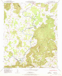 1947 Grant1970 Print · USGSNortheastern Alabama’s river valleys and mountain ridges are captured here just after the war, showing the rural landscape where three counties meet. Genealogists can trace family landmarks like Keel Cem, Butler Mill, and the many river crossings including Hellum Ford.4 unique versions available
 - 1948 Map of Paint Rock, 1966 Print
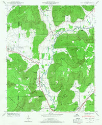 1948 Paint Rock1966 Print · USGSThe Paint Rock River valley in the late 1940s reveals a network of small Jackson County communities and riverside crossings. Genealogists and historians can locate numerous family burial sites like Latham Cem and trace the historic Southern RR past the Conyers-Rosenwald School.5 unique versions available
End of results
Showing maps 1-2 of 2
Top cities near Woodville
- Huntsville historical maps
- Scottsboro historical maps
- Guntersville historical maps
- New Hope historical maps
- Owens Cross Roads historical maps
- Grant historical maps
See more
Frequently asked questions
- What are the different types of historical maps available for Woodville?
- What is the oldest map of Woodville?
- Where can I purchase historical maps of Woodville for my home or office?
- Where can I download high-res historical maps of Woodville?
- Are there historical topographic maps available for Woodville?
- Is there historical aerial imagery available for Woodville?
- Where are historical maps of Woodville sourced from?