1990s Maps of Airport Highlands, Birmingham
Explore 1 historic maps of Airport Highlands from the 1990s. These maps offer a rare glimpse into what life looked like during the 1990s — showing old roads, neighborhoods, homes, and landmarks that have changed or disappeared over time.
Whether you're researching your family's past, planning a metal detecting trip, or studying how Airport Highlands's landscape evolved across the 1990s, these high-resolution maps are a powerful tool for exploring the history of this region.
- Focus on a specific era: All maps on this page are from the 1990s, giving you a focused view of this time period.
- See what’s changed: Compare century-old streets, trails, and buildings to today's modern landscape using overlays and satellite layers.
- Research with precision: Use these maps for genealogy, historical research, land use analysis, or educational projects.
- View, download, or print: Maps are fully viewable online in high resolution, and can be downloaded or printed for your own records.
Start exploring Airport Highlands's history through authentic maps from the 1990s. This is your window into the past.
Airport Highlands, Birmingham maps
(1)- 1998 Map of Irondale, 2001 Print
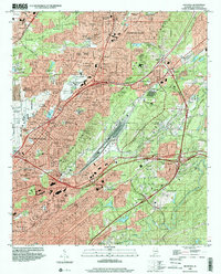 1998 Irondale2001 Print · USGSThe eastern Birmingham suburbs and the Irondale corridor are shown here in the late nineties as industrial landscapes began to meet sprawling residential growth. Genealogists and local historians can trace family plots in Forest Hill Cemetery or locate landmarks like the Alabama Industrial School for Boys and Gate City.
End of results
Showing maps 1-1 of 1
Top cities near Airport Highlands
- Birmingham historical maps
- Hoover historical maps
- Hoover historical maps
- Vestavia Hills historical maps
- Homewood historical maps
- Trussville historical maps
See more
Frequently asked questions
- What are the different types of historical maps available for Airport Highlands?
- What is the oldest map of Airport Highlands?
- Where can I purchase historical maps of Airport Highlands for my home or office?
- Where can I download high-res historical maps of Airport Highlands?
- Are there historical topographic maps available for Airport Highlands?
- Is there historical aerial imagery available for Airport Highlands?
- Where are historical maps of Airport Highlands sourced from?