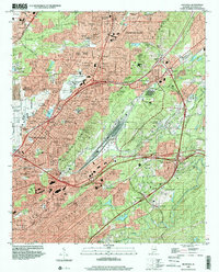
1998 Map of Irondale
USGS Topo · Published 2001About this map
Red Mountain and Shades Mountain form the high-relief backdrop for this late 20th-century view of the eastern Birmingham metropolitan area. The landscape is defined by its deep industrial roots and post-war suburban growth, centered on the Irondale and Birmingham city boundaries. The industrial legacy is visible in the strip mines and gravel pits near Ruffner Mountain, while the residential expansion is evident in neighborhoods like Roebuck, Huffman, and Crestline Park. Transport corridors including the Norfolk Southern railroad and Interstate 59 cut through the Shades Valley, connecting the city to its municipal outskirts and the Birmingham Municipal Airport. Local social history is grounded in numerous community landmarks, from the Alabama Industrial School for Boys and Banks High School to historic burial grounds like Forest Hill Cemetery and Jefferson Memorial Gardens.
Find a feature on this map
137 named features on this map. Tap any name to fly to it.
Don’t see what you’re looking for? This feature index may not catch every label — zoom into the map to look around manually.
Map Details
Editions of this 1998 Irondale Map
This is the sole edition of this map. No revisions or reprints were ever made.
Other maps of this area

1889 · Birmingham
USGS Topo · 1:125,000

1890 · Bessemer
USGS Topo · 1:125,000

1892 · Birmingham
USGS Topo · 1:125,000

1892 · Bessemer
USGS Topo · 1:125,000

1895 · Birmingham
USGS Topo · 1:125,000

1904 · Birmingham Coal District
USGS Topo · 1:62,500

1905 · Bessemer Iron District
USGS Topo · 1:62,500

1905 · Leeds
USGS Topo · 1:62,500

1906 · Birmingham Special
USGS Topo · 1:62,500

1906 · Vandiver
USGS Topo · 1:62,500