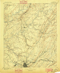
1892 Map of Birmingham
USGS Topo · Published 1892About this map
Birmingham stands at the center of this industrial landscape during the late nineteenth century, surrounded by a burgeoning network of railroads and mining operations. The city grid is clearly defined, with neighboring communities like Avondale, Woodlawn, and East Birmingham established along the rail lines. Industrial sites such as the Sloss Mine, Sloss Quarry, and the Old Irondale Furnace reflect the region's iron and coal foundations. Beyond the urban core, the terrain is shaped by Sand Mountain and the Locust Fork of Black Warrior River, where numerous river crossings like Doss Ferry, Brake Ferry, and Baltimore Ford provided essential connectivity before the age of modern bridges.
Find a feature on this map
184 named features on this map. Tap any name to fly to it.
Don’t see what you’re looking for? This feature index may not catch every label — zoom into the map to look around manually.
Map Details
Editions of this 1892 Birmingham Map
This is the sole edition of this map. No revisions or reprints were ever made.
Historical Maps of Birmingham Through Time
7 maps found