1930s Maps of Johns, Alabama
Explore 2 historic maps of Johns from the 1930s. These maps offer a rare glimpse into what life looked like during the 1930s — showing old roads, neighborhoods, homes, and landmarks that have changed or disappeared over time.
Whether you're researching your family's past, planning a metal detecting trip, or studying how Johns's landscape evolved across the 1930s, these high-resolution maps are a powerful tool for exploring the history of this region.
- Focus on a specific era: All maps on this page are from the 1930s, giving you a focused view of this time period.
- See what’s changed: Compare century-old streets, trails, and buildings to today's modern landscape using overlays and satellite layers.
- Research with precision: Use these maps for genealogy, historical research, land use analysis, or educational projects.
- View, download, or print: Maps are fully viewable online in high resolution, and can be downloaded or printed for your own records.
Start exploring Johns's history through authentic maps from the 1930s. This is your window into the past.
Johns, AL maps
(2)- 1932 Map of Yolande, 1964 Print
 1932 Yolande1964 Print · USGSThe industrial corridor southwest of Birmingham comes alive in this survey of the early thirties, where coal and iron roots run deep. Trace the rail lines serving Gilmore Mines and Connellsville or locate family sites near McCalla and Yolande.
 - 1935 Map of Yolande
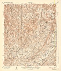 1935 Yolande1935 Print · USGSThe Jefferson and Tuscaloosa county line was a hub of coal production and rail activity in the 1930s. Researchers can trace the layout of mining communities like Yolande and Johns or locate family roots at Dogwood Ch and Kniss Store.3 unique versions available
End of results
Showing maps 1-2 of 2
Top cities near Johns
- Birmingham historical maps
- Tuscaloosa historical maps
- Hoover historical maps
- Bessemer historical maps
- Helena historical maps
- Hueytown historical maps
See more
Frequently asked questions
- What are the different types of historical maps available for Johns?
- What is the oldest map of Johns?
- Where can I purchase historical maps of Johns for my home or office?
- Where can I download high-res historical maps of Johns?
- Are there historical topographic maps available for Johns?
- Is there historical aerial imagery available for Johns?
- Where are historical maps of Johns sourced from?