1970s Maps of Leeds, Alabama
Explore 4 historic maps of Leeds from the 1970s. These maps offer a rare glimpse into what life looked like during the 1970s — showing old roads, neighborhoods, homes, and landmarks that have changed or disappeared over time.
Whether you're researching your family's past, planning a metal detecting trip, or studying how Leeds's landscape evolved across the 1970s, these high-resolution maps are a powerful tool for exploring the history of this region.
- Focus on a specific era: All maps on this page are from the 1970s, giving you a focused view of this time period.
- See what’s changed: Compare century-old streets, trails, and buildings to today's modern landscape using overlays and satellite layers.
- Research with precision: Use these maps for genealogy, historical research, land use analysis, or educational projects.
- View, download, or print: Maps are fully viewable online in high resolution, and can be downloaded or printed for your own records.
Start exploring Leeds's history through authentic maps from the 1970s. This is your window into the past.
Leeds, AL maps
(4)- 1975 Map of Irondale, 1977 Print
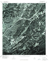 1975 Irondale1977 Print · USGSThe industrial and residential growth of Jefferson County is visible in this mid-seventies aerial survey, showing the landscape just as the modern interstate system matured. Trace the development of Irondale and its surrounding ridge-and-valley terrain.
 - 1975 Map of Cooks Springs, 1977 Print
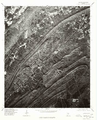
 1975 Cooks Springs1977 Print · USGSSt. Clair County appears in high-detail aerial imagery during the mid-seventies, showing the ridge-and-valley landscape of central Alabama. Genealogists and historians can pinpoint homesites and property boundaries near Cooks Springs, Moody, and Prescott.
 - 1975 Map of Vandiver, 1977 Print
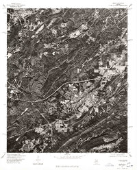
 1975 Vandiver1977 Print · USGSShelby County land patterns and ridge-top forests are revealed in this 1970s aerial study. Local historians and genealogists can trace property boundaries and rural roads around Vandiver and the waters of Wehapa Lake.
 - 1975 Map of Leeds, 1977 Print
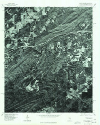
 1975 Leeds1977 Print · USGSJefferson County during the mid-seventies shows a landscape of growing towns and industrial sites set against the sharp ridges of central Alabama. Trace the development of Leeds and Trussville through direct aerial imagery from this era.
End of results
Showing maps 1-4 of 4
Top cities near Leeds
- Birmingham historical maps
- Hoover historical maps
- Vestavia Hills historical maps
- Homewood historical maps
- Trussville historical maps
- Pelham historical maps
See more
Top neighborhoods of Leeds
- Cahaba Hills historical maps
- Maplewood historical maps
- Oak Crossing historical maps
- Austin Hill historical maps
Frequently asked questions
- What are the different types of historical maps available for Leeds?
- What is the oldest map of Leeds?
- Where can I purchase historical maps of Leeds for my home or office?
- Where can I download high-res historical maps of Leeds?
- Are there historical topographic maps available for Leeds?
- Is there historical aerial imagery available for Leeds?
- Where are historical maps of Leeds sourced from?