1910s Maps of Sky Park, Alabama
Explore 2 historic maps of Sky Park from the 1910s. These maps offer a rare glimpse into what life looked like during the 1910s — showing old roads, neighborhoods, homes, and landmarks that have changed or disappeared over time.
Whether you're researching your family's past, planning a metal detecting trip, or studying how Sky Park's landscape evolved across the 1910s, these high-resolution maps are a powerful tool for exploring the history of this region.
- Focus on a specific era: All maps on this page are from the 1910s, giving you a focused view of this time period.
- See what’s changed: Compare century-old streets, trails, and buildings to today's modern landscape using overlays and satellite layers.
- Research with precision: Use these maps for genealogy, historical research, land use analysis, or educational projects.
- View, download, or print: Maps are fully viewable online in high resolution, and can be downloaded or printed for your own records.
Start exploring Sky Park's history through authentic maps from the 1910s. This is your window into the past.
Sky Park, AL maps
(2)- 1914 Map of Muscle Shoals
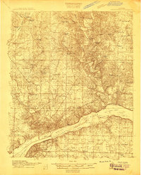 1914 Muscle Shoals1914 Print · USGSThe Tennessee River and its complex shoals define the Shoals region in the years before major damming projects. Trace the Muscle Shoals Canal and find landmarks like St Florian, Mars Hill School, and Lock No 6.
 - 1916 Map of Muscle Shoals
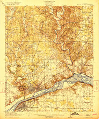 1916 Muscle Shoals1916 Print · USGSThe Tennessee River corridor around Florence and Sheffield appears here in the years before dam construction altered the valley forever. Researchers can trace historic river crossings like Goose Shoals Ford, early navigation locks, and vanished community hubs such as Big Cut Hines PO.2 unique versions available
End of results
Showing maps 1-2 of 2
Top cities near Sky Park
- Florence historical maps
- Muscle Shoals historical maps
- Sheffield historical maps
- Tuscumbia historical maps
- Underwood-Petersville historical maps
- Loretto historical maps
See more
Frequently asked questions
- What are the different types of historical maps available for Sky Park?
- What is the oldest map of Sky Park?
- Where can I purchase historical maps of Sky Park for my home or office?
- Where can I download high-res historical maps of Sky Park?
- Are there historical topographic maps available for Sky Park?
- Is there historical aerial imagery available for Sky Park?
- Where are historical maps of Sky Park sourced from?