1914 Map of Muscle Shoals
USGS Topo · Published 1914About this map
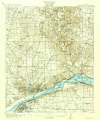
The Tennessee River dominates this landscape, showing the complex navigation system required to traverse the Big Muscle Shoals before the river was dammed. The Muscle Shoals Canal and Lock No 6 illustrate the industrial efforts to bypass these dangerous rapids, which are dotted with landforms like Polk Stalk I and Jacksons Island. To the north, the industrial hubs of Florence and Sheffield are shown during a period of significant growth, connected by the Southern railroad and the Cloverdale Road.
Find a feature on this map
69 named features on this map. Tap any name to fly to it.
Don’t see what you’re looking for? This feature index may not catch every label — zoom into the map to look around manually.
Map Details
Editions of this 1914 Muscle Shoals Map
This is the sole edition of this map. No revisions or reprints were ever made.