
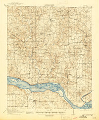
1916 Map of Rogersville
USGS Topo · Published 1916About this map
The Tennessee River corridor in Northwest Alabama serves as the centerpiece of this 1916 survey, just before the major hydroelectric developments changed the river's profile forever. The landscape is defined by the complex Muscle Shoals Canal system and a dense network of early 20th-century rural infrastructure, including many family-named landmarks like Mitchells Mill and Ingram Mill. This era shows the region still heavily reliant on water-driven industry and river crossings like Lambs Ferry at the mouth of the Elk River.
Find a feature on this map
63 named features on this map. Tap any name to fly to it.
Don’t see what you’re looking for? This feature index may not catch every label — zoom into the map to look around manually.
Map Details
Editions of this 1916 Rogersville Map
2 editions found
Other maps of this area

1905 · Waynesboro
USGS Topo · 1:125,000

1914 · Rogersville
USGS Topo · 1:48,000

1914 · Muscle Shoals
USGS Topo · 1:48,000

1916 · Muscle Shoals
USGS Topo · 1:62,500

1924 · Tuscumbia
USGS Topo · 1:48,000

1926 · Tuscumbia
USGS Topo · 1:62,500

1936 · Union Hill
USGS Topo · 1:24,000

1936 · Thorntontown
USGS Topo · 1:24,000

1936 · Courtland
USGS Topo · 1:24,000

1936 · Lexington
USGS Topo · 1:24,000