
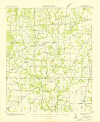
1936 Map of Lexington
USGS Topo · Published 1936About this map
Lexington and Anderson anchor this Lauderdale County landscape during the mid-1930s, a period when the Tennessee Valley Authority was actively reshaping the region's infrastructure. This survey captures a rural network defined by its small community centers and an extensive system of creeks and branches, such as Second Creek and Anderson Creek. The map provides significant genealogical value through its documentation of rural institutions, including the Portertown School and Portertown Cemetery in the north, and Howard School further south. Local industry and basic utility are visible in the form of the Ingram Mill and a prominent Power Transmission Line cutting north-to-south across the quadrangle. Smaller settlements like Grassy and Whitehead are shown alongside numerous country houses of worship, such as Oxford Church and Nebo Church, reflecting the era's decentralized social structure.
Find a feature on this map
42 named features on this map. Tap any name to fly to it.
Don’t see what you’re looking for? This feature index may not catch every label — zoom into the map to look around manually.
Map Details
Editions of this 1936 Lexington Map
This is the sole edition of this map. No revisions or reprints were ever made.
Other maps of this area

1914 · Rogersville
USGS Topo · 1:48,000

1916 · Rogersville
USGS Topo · 1:62,500

1936 · Union Hill
USGS Topo · 1:24,000

1936 · Thorntontown
USGS Topo · 1:24,000

1936 · Loretto
USGS Topo · 1:24,000

1936 · Wheeler Dam
USGS Topo · 1:24,000
1936 · Center Hill
USGS Topo · 1:24,000

1936 · Appleton
USGS Topo · 1:24,000

1936 · Cairo
USGS Topo · 1:24,000

1936 · Bonnertown
USGS Topo · 1:24,000