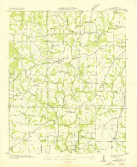
1936 Map of Center Hill
USGS Topo · Published 1936About this map
Center Hill serves as a central point in this northern Alabama landscape, situated just before the profound changes brought by the Tennessee Valley Authority. The map reveals a deeply established rural network of small family-named landmarks and civic foundations, including the Richardson Chapel Cem and Hickory Flats Ch Cem. Small settlements like Mitchelltown and Kingtown are connected by roads that wind alongside Bluewater Creek and Hurricane Creek, reflecting a community structure built around watercourses and local timber. The distribution of numerous one-room schoolhouses, such as Palestine Sch and Green Hill Sch, alongside country churches like Mary Chapel and Green Chapel, highlights the localized social geography of Lauderdale County in the mid-1930s. A single Power Line crossing the terrain signals the early technological modernization of the Tennessee Valley during this period.
Find a feature on this map
51 named features on this map. Tap any name to fly to it.
Don’t see what you’re looking for? This feature index may not catch every label — zoom into the map to look around manually.
Map Details
Editions of this 1936 Center Hill Map
This is the sole edition of this map. No revisions or reprints were ever made.
Other maps of this area

1905 · Waynesboro
USGS Topo · 1:125,000

1914 · Rogersville
USGS Topo · 1:48,000

1914 · Muscle Shoals
USGS Topo · 1:48,000

1916 · Muscle Shoals
USGS Topo · 1:62,500

1916 · Rogersville
USGS Topo · 1:62,500

1936 · Thorntontown
USGS Topo · 1:24,000

1936 · Lexington
USGS Topo · 1:24,000

1936 · Loretto
USGS Topo · 1:24,000

1936 · Pruitton
USGS Topo · 1:24,000

1936 · Wheeler Dam
USGS Topo · 1:24,000