
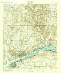
1916 Map of Muscle Shoals
USGS Topo · Published 1916About this map
The Tennessee River dominates this landscape just before the construction of massive hydroelectric dams, revealing the natural rapids of Muscle Shoals and Little Muscle Shoals. In this era, navigation through the shoals was managed by a series of river improvements, including Lock No 6 and Lock No 9. Along the northern banks, the growing city of Florence and neighboring Sheffield serve as industrial and rail hubs, connected by the Louisville and Nashville and Southern railroads. Rural life across Lauderdale County is documented through numerous country schools like Mt Zion School and Bush Arbor School, while old river crossings such as Section Ford and Savannah Ford reflect a reliance on natural geography. Notable local landmarks like Bailey Springs and the post office at Big Cut Hines PO provide specific points of interest for genealogists and local historians.
Find a feature on this map
73 named features on this map. Tap any name to fly to it.
Don’t see what you’re looking for? This feature index may not catch every label — zoom into the map to look around manually.
Map Details
Editions of this 1916 Muscle Shoals Map
2 editions found
Other maps of this area

1905 · Waynesboro
USGS Topo · 1:125,000

1914 · Rogersville
USGS Topo · 1:48,000

1914 · Muscle Shoals
USGS Topo · 1:48,000

1916 · Rogersville
USGS Topo · 1:62,500

1924 · Tuscumbia
USGS Topo · 1:48,000

1924 · Gravelly Springs
USGS Topo · 1:48,000

1925 · Barton
USGS Topo · 1:62,500

1926 · Tuscumbia
USGS Topo · 1:62,500

1926 · Barton
USGS Topo · 1:48,000

1926 · Gravelly Springs
USGS Topo · 1:62,500