Loading...
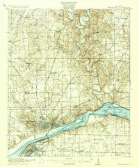
Loading map...1916 Map of Muscle Shoals
USGS Topo · Published 1916About this map
Florence and Sheffield anchor this 1916 survey of the Tennessee River valley, captured just before massive industrial and hydroelectric projects forever altered the river's character. The complex geography of the Big Muscle Shoals dominates the southern portion of the map, revealing a series of navigational aids including the Muscle Shoals Canal and its series of Lock No 6, Lock No 7, Lock No 8, and Lock No 9. These features reflect the era's ongoing struggle to bypass the treacherous rapids that hampered river commerce.
Find a feature on this map
70 named features on this map. Tap any name to fly to it.
Don’t see what you’re looking for? This feature index may not catch every label — zoom into the map to look around manually.
Map Details
Date Portrayed1916
Date Published1916
PublisherU.S. Geological Survey
Map TypeTopographic
Scale1:62,500
Physical Dimensions16.5 x 19.8 inches
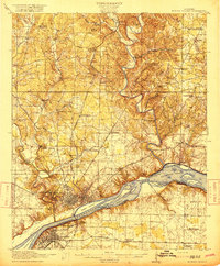
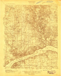
Editions of this 1916 Muscle Shoals Map
2 editions found
Historical Maps of Florence Through Time
Featured Locations
Source Details
SourceU.S. Geological Survey
CopyrightPublic Domain