Old Maps of Beulah Land, Alabama for Academic Research
Study the evolution of Beulah Land with 13 high-resolution historic maps. Whether you're teaching, researching, or modeling changes in land use, these maps provide essential visual documentation of urban, environmental, and geographic change.
- Analyze long-term change: Track patterns in development, transportation, and natural features.
- Ideal for environmental or urban studies: Support academic projects with primary historical map data.
- Use in the classroom or lab: Educators and researchers rely on these maps to bring historical context to life.
These maps are a powerful tool for teaching, research, and visualizing how Beulah Land has changed over the decades.
Beulah Land, AL maps
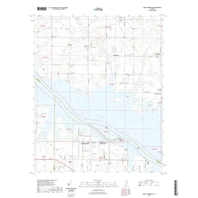
(13)- 1936 Map of Stewart Cross Roads
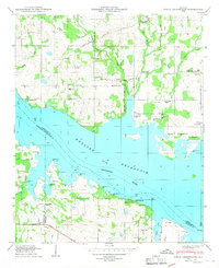
 1936 Stewart Cross Roads1936 Print · USGSThe Tennessee River valley underwent a massive transformation in the mid-1930s as the new reservoir flooded the lowlands. You can trace submerged riverbanks and find upland landmarks like Stewart Cross Roads, Beulah Land, and St Luke Sch.
 - 1950 Map of Jones Crossroads
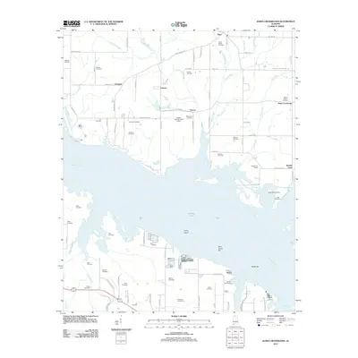
 1950 Jones Crossroads1950 Print · USGSLimestone and Morgan counties meet along the wide waters of the Tennessee River in the post-war era. Genealogists and local historians can trace family plots at Neville Cem or locate community centers like Jones Crossroads and the Pine Ridge School.3 unique versions available
 - 1956 Map of Gadsden, 1966 Print
 1956 Gadsden1966 Print · USGSNorth Alabama in the mid-1950s shows a region transformed by river engineering and federal industry. Genealogists and local historians can trace the development of the Tennessee Valley through the growth of Huntsville, the sprawling Redstone Arsenal, and the expansive Guntersville Lake.3 unique versions available
 - 1958 Map of Gadsden
 1958 Gadsden1958 Print · USGSNorth Alabama comes alive in the late 1950s as the Tennessee Valley Authority’s massive river projects and the rise of the space industry reshaped the landscape. Researchers can trace the mid-century footprints of Huntsville, Redstone Arsenal, and the riverside rail networks of the Southern railroad.
 - 1960 Map of Gadsden
 1960 Gadsden1960 Print · USGSNorthern Alabama in the mid-1950s is defined by the mighty Tennessee River and its massive reservoirs. Trace the development of Huntsville and Redstone Arsenal or explore the vast William B Bankhead National Forest.2 unique versions available
 - 1963 Map of Gadsden
 1963 Gadsden1963 Print · USGSNorthern Alabama underwent a dramatic mid-century transformation as the Tennessee Valley became a hub for defense and industry. Researchers can trace the development of the Redstone Arsenal, the route of the Natchez Trace Parkway, and long-standing rail lines like the Southern Railway.
 - 1976 Map of Jones Crossroads, 1977 Print
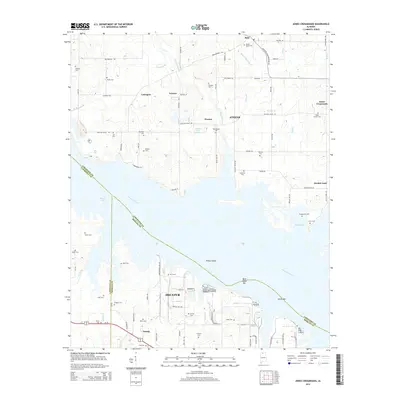
 1976 Jones Crossroads1977 Print · USGSThe Tennessee River valley north of Decatur underwent significant industrial transformation by the mid-seventies. Researchers can trace family history through numerous burial sites like Malone Cem or locate the sprawling Browns Ferry Nuclear Plant.
 - 1986 Map of Tuscumbia
 1986 Tuscumbia1986 Print · USGSThe Tennessee River valley in the mid-1980s shows a landscape transformed by massive reservoirs and industrial hubs. Genealogists and local historians can trace the development of the Shoals area and locate rural communities like Tharp Town, Leighton, and Rogersville.3 unique versions available
 - 2011 Map of Jones Crossroads, 2011 Print
 2011 Jones Crossroads2011 Print · USGSCovers Beulah Land, including Decatur, Athens, and other nearby areas
 - 2014 Map of Jones Crossroads, 2014 Print
 2014 Jones Crossroads2014 Print · USGSCovers Beulah Land, including Decatur, Athens, and other nearby areas
 - 2018 Map of Jones Crossroads, 2018 Print
 2018 Jones Crossroads2018 Print · USGSCovers Beulah Land, including Decatur, Athens, and other nearby areas
 - 2020 Map of Jones Crossroads, 2020 Print
 2020 Jones Crossroads2020 Print · USGSCovers Beulah Land, including Decatur, Athens, and other nearby areas
 - 2024 Map of Jones Crossroads, 2024 Print
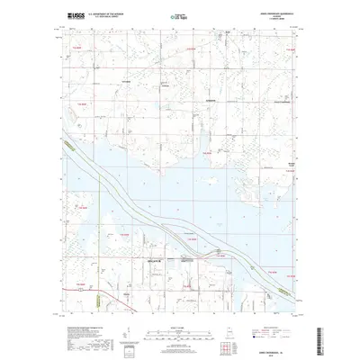
 2024 Jones Crossroads2024 Print · USGSThis recent survey of the Tennessee River shoreline in Northern Alabama details the communities surrounding Athens and Decatur. Researchers can trace numerous family-named landmarks and cemeteries, from Oak Grove Cem to Malone Cem and the riverfront at Heints Bar.
End of results
Showing maps 1-13 of 13
Top cities near Beulah Land
- Huntsville historical maps
- Decatur historical maps
- Madison historical maps
- Athens historical maps
- Hartselle historical maps
- Priceville historical maps
See more
Frequently asked questions
- What are the different types of historical maps available for Beulah Land?
- What is the oldest map of Beulah Land?
- Where can I purchase historical maps of Beulah Land for my home or office?
- Where can I download high-res historical maps of Beulah Land?
- Are there historical topographic maps available for Beulah Land?
- Is there historical aerial imagery available for Beulah Land?
- Where are historical maps of Beulah Land sourced from?