1900s (20th Century) Maps of Chehaw, Alabama
Explore 6 historic maps of Chehaw from the 1900s (20th Century). These maps offer a rare glimpse into what life looked like during the 1900s — showing old roads, neighborhoods, homes, and landmarks that have changed or disappeared over time.
Whether you're researching your family's past, planning a metal detecting trip, or studying how Chehaw's landscape evolved across the 1900s, these high-resolution maps are a powerful tool for exploring the history of this region.
- Focus on a specific era: All maps on this page are from the 1900s, giving you a focused view of this time period.
- See what’s changed: Compare century-old streets, trails, and buildings to today's modern landscape using overlays and satellite layers.
- Research with precision: Use these maps for genealogy, historical research, land use analysis, or educational projects.
- View, download, or print: Maps are fully viewable online in high resolution, and can be downloaded or printed for your own records.
Start exploring Chehaw's history through authentic maps from the 1900s. This is your window into the past.
Chehaw, AL maps
(6)- 1955 Map of Phenix City, 1964 Print
 1955 Phenix City1964 Print · USGSPost-war Alabama and Georgia meet along the Chattahoochee River as industry and military installations expand. Trace the rail lines of the Central of Georgia through towns like Opelika, Tuskegee, and Alexander City.3 unique versions available
 - 1957 Map of Phenix City
 1957 Phenix City1957 Print · USGSThe Alabama-Georgia borderlands are captured here in the mid-fifties, centered on the bustling river crossing at Phenix City and Columbus. Researchers can trace the mid-century footprint of the Fort Benning Military Reservation or locate smaller textile and railroad towns like Langdale and Camp Hill.
 - 1958 Map of Phenix City
 1958 Phenix City1958 Print · USGSThe Alabama-Georgia borderlands thrive during the late fifties, anchored by the river-driven industry of Columbus and Phenix City. Researchers can trace the mid-century footprints of Fort Benning, Auburn, and the textile towns of Fairfax and Lanett.
 - 1971 Map of Tuskegee, 1973 Print
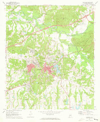 1971 Tuskegee1973 Print · USGSTuskegee and its famed institute are documented here in the early 1970s, showcasing a period of significant institutional and civic growth. Researchers can locate specific sites from the Tuskegee Institute campus to the Veterans Hospital and Moton Field.3 unique versions available
 - 1981 Map of Tuskegee, 1982 Print
 1981 Tuskegee1982 Print · USGSMacon and Bullock counties are captured here in the early eighties, showcasing a landscape deeply tied to the railroad and the legacies of Tuskegee Institute. Researchers can locate specific sites from Moton Field to rural settlements along the Seaboard Coast Line like Hurtsboro and Pittsview.2 unique versions available
 - 1998 Map of Tuskegee, 2001 Print
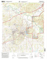 1998 Tuskegee2001 Print · USGSTuskegee and the nearby national forest lands are shown here in the late nineties, documenting a landscape of deep educational and civic history. Researchers can trace the grounds of the Tuskegee Institute, locate Moton Field, and find family sites like Greenwood Cem.
End of results
Showing maps 1-6 of 6
Top cities near Chehaw
- Auburn historical maps
- Tuskegee historical maps
- Tallassee historical maps
- Notasulga historical maps
- Reeltown historical maps
- Franklin historical maps
See more
Frequently asked questions
- What are the different types of historical maps available for Chehaw?
- What is the oldest map of Chehaw?
- Where can I purchase historical maps of Chehaw for my home or office?
- Where can I download high-res historical maps of Chehaw?
- Are there historical topographic maps available for Chehaw?
- Is there historical aerial imagery available for Chehaw?
- Where are historical maps of Chehaw sourced from?