1940s Maps of Gurley Historic District, Gurley
Explore 2 historic maps of Gurley Historic District from the 1940s. These maps offer a rare glimpse into what life looked like during the 1940s — showing old roads, neighborhoods, homes, and landmarks that have changed or disappeared over time.
Whether you're researching your family's past, planning a metal detecting trip, or studying how Gurley Historic District's landscape evolved across the 1940s, these high-resolution maps are a powerful tool for exploring the history of this region.
- Focus on a specific era: All maps on this page are from the 1940s, giving you a focused view of this time period.
- See what’s changed: Compare century-old streets, trails, and buildings to today's modern landscape using overlays and satellite layers.
- Research with precision: Use these maps for genealogy, historical research, land use analysis, or educational projects.
- View, download, or print: Maps are fully viewable online in high resolution, and can be downloaded or printed for your own records.
Start exploring Gurley Historic District's history through authentic maps from the 1940s. This is your window into the past.
Gurley Historic District, Gurley maps
(2)- 1948 Map of Moontown, 1952 Print
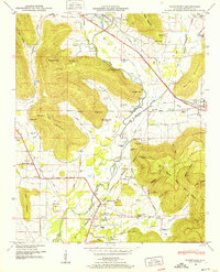 1948 Moontown1952 Print · USGSMadison County's valley floor and mountain ridges appear here in the late 1940s, showing a landscape defined by the FLINT RIVER and small agricultural settlements. Researchers can locate vanished landmarks like Sublett Mill, the Big Cove School, and numerous family cemeteries including Lawler Cem and Stanford Cem.5 unique versions available
 - 1948 Map of Paint Rock, 1966 Print
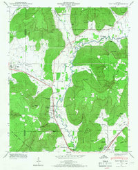 1948 Paint Rock1966 Print · USGSThe Paint Rock River valley in the late 1940s reveals a network of small Jackson County communities and riverside crossings. Genealogists and historians can locate numerous family burial sites like Latham Cem and trace the historic Southern RR past the Conyers-Rosenwald School.5 unique versions available
End of results
Showing maps 1-2 of 2
Frequently asked questions
- What are the different types of historical maps available for Gurley Historic District?
- What is the oldest map of Gurley Historic District?
- Where can I purchase historical maps of Gurley Historic District for my home or office?
- Where can I download high-res historical maps of Gurley Historic District?
- Are there historical topographic maps available for Gurley Historic District?
- Is there historical aerial imagery available for Gurley Historic District?
- Where are historical maps of Gurley Historic District sourced from?