Old Maps of Madison County, Alabama
Explore 208 old maps of Madison County, spanning from 1885 to today. These high-resolution historic maps reveal how streets, neighborhoods, landmarks, and natural features evolved over time — perfect for genealogy, metal detecting, research, and local history exploration.
What you can do with these maps:
- See how Madison County changed over time: Compare historical maps to modern-day views to trace roads, homesites, rail lines & more.
- View detailed metadata: Each map includes creators, publishers, year, scale, and archive source.
- Overlay maps with satellite & LiDAR: Visualize the past alongside modern tools to explore terrain & human change.
- Trusted historical sources: Maps sourced from the USGS, Library of Congress, and other archives.
- Access maps your way: View online, download high-res files, or order prints for personal or research use.
Start exploring old maps of Madison County to uncover forgotten places, hidden landmarks, and the deep history beneath your feet.
Madison County, AL maps
(208)- 1885 Map of Gadsden
 1885 Gadsden1885 Print · USGSNortheast Alabama in the mid-1880s was a landscape of river-side landings and emerging rail towns. Genealogists and historians can trace the early foundations of Guntersville and Gadsden while locating rural landmarks like Hillian Store, Cottonville, and Law Landing.
 - 1888 Map of Cullman
 1888 Cullman1888 Print · USGSCullman and Morgan counties are shown in the late 1880s as the railroad fueled growth across the Sand Mountain region. Genealogists can trace early homesteads and commerce at Sobotka's Mill, Fort Bluff, and the riverside town of Blountsville.
 - 1888 Map of Gadsden
 1888 Gadsden1888 Print · USGSNorth Alabama's river valleys and plateau lands are captured here in the late nineteenth century as the region transitioned from river landings to rail transport. Researchers can locate early post offices and commerce centers like Hillian's Store, Guntersville, and the ferry at Ft Deposit.
 - 1888 Map of Scottsboro
 1888 Scottsboro1888 Print · USGSNortheast Alabama is shown in the late nineteenth century as a land of steep plateaus and vital river crossings. Genealogists and researchers can trace the early rail-and-river economy through family landmarks like Caldwell's Ferry and the Bell Factory textile site.
 - 1888 Map of Huntsville
 1888 Huntsville1888 Print · USGSMadison and Limestone counties in the late 1880s showcase a landscape defined by the Tennessee River and major early rail lines. Researchers can trace the layout of Huntsville or locate long-standing communities like Mooresville and Thompsons Mill.
 - 1892 Map of Cullman
 1892 Cullman1892 Print · USGSNorth-central Alabama's development is centered on the railroad corridor and rugged plateau country in the late nineteenth century. Genealogists can trace family footprints at Sobotka's Mill, along the historic Stout's Road, or near the remote Newsome Sinks.4 unique versions available
 - 1892 Map of Huntsville
 1892 Huntsville1892 Print · USGSNorth Alabama was a landscape of river ferries and rising rail hubs in the 1890s, caught here just as the region's industry began to modernize. Researchers can locate vanished landmarks like the Monte Sano Hotel and trace old family-named sites from Thompsons Mill to Lemans Ferry.6 unique versions available
 - 1892 Map of Scottsboro
 1892 Scottsboro1892 Print · USGSJackson County and the Tennessee River valley are captured here in the late nineteenth century, just as railroads began to reshape local commerce. Genealogists can trace family-named sites like Owen's Cross Roads, Carrick Mill, and Larkin Landing.5 unique versions available
 - 1892 Map of Gadsden
 1892 Gadsden1892 Print · USGSNorth Alabama's river-and-rail economy is captured here in the late nineteenth century as Guntersville and Gadsden emerge as regional hubs. Genealogists and historians can trace the routes of the Birmingham Mineral R. R. or locate old community centers like Cottonville and Mt Zion.
 - 1895 Map of Gadsden
 1895 Gadsden1895 Print · USGSNortheast Alabama at the close of the century was a landscape of river landings and mountain gaps where the Tennessee River met growing rail hubs. Genealogists can trace family holdings near Hillian Store, Cottonville, and the remote heights of Lookout Mountain.
 - 1903 Map of Gadsden
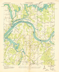
 1903 Gadsden1903 Print · USGSNorthern Alabama in the late nineteenth century centers on the busy Tennessee River corridor and its surrounding ridges. Trace old family sites and transport hubs like Hillian Store, Lovelace Landing, and the Mt Zion church.4 unique versions available
 - 1936 Map of Jeff
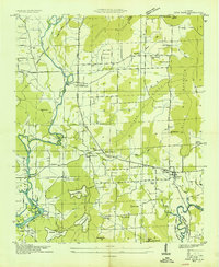
 1936 Jeff1936 Print · USGSMadison County rural life is captured in the mid-1930s, showing a landscape defined by ancestral lines and small-town centers. Trace family roots through Indian Creek Cem, St John Cem, and old schools like Little Indian Creek Sch.
 - 1936 Map of King Cove
 1936 King Cove1936 Print · USGSThe Alabama-Tennessee borderlands appear here in the mid-1930s, showing a landscape of high ridges and isolated mountain coves. Researchers can locate family landmarks like Crowell Cem and Maxwell Cem or rural centers like Howard Hill Sch.
 - 1936 Map of Capshaw
 1936 Capshaw1936 Print · USGSLimestone and Madison counties are captured here in the mid-1930s as the Tennessee Valley Authority and Alabama Power began modernizing the rural landscape. Researchers can locate numerous vanished country schools like Grimett Sch, family landmarks such as McCully Mill, and the community at Wesley Chapel.
 - 1936 Map of Triana
 1936 Triana1936 Print · USGSThe Tennessee River bend near the Madison and Morgan county line is captured here just as the Tennessee Valley Authority era began. Researchers can trace the layout of early rural school districts like Horton Sch and Union Sch or locate congregations at Mt Mariah Ch and Talucah Ch.
 - 1936 Map of New Hope
 1936 New Hope1936 Print · USGSThe Flint River valley in the mid-1930s shows a landscape on the brink of change as the Wheeler Reservoir reaches its high-water mark. Researchers can locate family landmarks like Baker Cem, Owens Cross Roads, and local hubs like Buggs Chapel or Cherokee School.
 - 1936 Map of Guntersville Dam
 1936 Guntersville Dam1936 Print · USGSMarshall County is captured during the transformative construction of the TVA system in the mid-1930s. Researchers can locate landmarks like Neighbors Mill, the Construction Camp, and old schools including Mobbs Sch and Lamont Sch.
 - 1936 Map of Madison
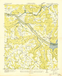
 1936 Madison1936 Print · USGSMadison and its surrounding farmstead landscape are captured in the mid-1930s just as the Tennessee Valley Authority began transforming the river valley. Researchers can locate numerous vanished landmarks like Lankford Mill, trace the CHICKASAW BOUNDARY, and find family sites near Brandontown or Fuller Chapel.
 - 1936 Map of Meridianville
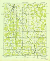
 1936 Meridianville1936 Print · USGSMadison County in the mid-1930s is shown here as a landscape of crossroads settlements and small farm communities connected by multiple rail lines. Genealogists and local historians can trace family roots through numerous sites like Pope Cem, Taylor Chapel, and the Meridianville Bottom Sch.
 - 1936 Map of Moontown
 1936 Moontown1936 Print · USGSMadison County at the height of the Great Depression is captured here as a landscape of small river towns and mountain hollows. Family historians can trace ancestral locations near Sublett Mill, Adair Ford, or several rural congregations like Acklin Ch.
 - 1936 Map of Fisk
 1936 Fisk1936 Print · USGSThe Alabama-Tennessee borderlands north of Huntsville appear here during the mid-thirties, showing a rural landscape of dispersed farmsteads and small crossroads. Genealogists can trace family roots through sites like Driskill Cem, St Rebecca Ch, and Farmers Capital Sch.
 - 1936 Map of Hollytree
 1936 Hollytree1936 Print · USGSJackson County, Alabama, was a landscape of mountain coves and limestone sinks in the mid-1930s. Genealogists and hikers can trace old family footprints at Hollytree, locate rural landmarks like Pleas Mount Ch, or explore the terrain around Aladdin Cave and Bingham Narrows.
 - 1936 Map of Ardmore
 1936 Ardmore1936 Print · USGSThe Alabama-Tennessee borderlands appear here in the mid-1930s, showing the early growth of ARDMORE along the LOUISVILLE AND NASHVILLE railroad. Genealogists can trace family landmarks like Hatchett Cem and rural school sites such as Wooley Springs Sch.
 - 1936 Map of Grant
 1936 Grant1936 Print · USGSAs the mid-1930s brought the Tennessee Valley Authority to Marshall County, this area balanced its mountain heritage with new river developments. Genealogists and researchers can trace family landmarks like Butlers Mill, Fishtrap Ford, and the DAR Sch.
 - 1936 Map of Toney
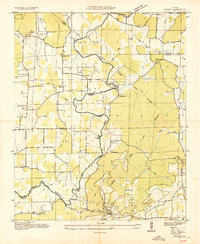
 1936 Toney1936 Print · USGSThe Tennessee-Alabama borderlands come into focus in the mid-1930s, showing a rural landscape defined by the Brier Fork Flint River. Genealogists can trace family names at Golightly Cem and Ready Cem or locate community hubs like New Sharon and Leas Store.
Showing maps 1-25 of 208
Top cities of Madison County
- Huntsville historical maps
- Meridianville historical maps
- Moores Mill historical maps
- Harvest historical maps
- Hazel Green historical maps
- Triana historical maps
See more
Frequently asked questions
- What are the different types of historical maps available for Madison County?
- What is the oldest map of Madison County?
- Where can I purchase historical maps of Madison County for my home or office?
- Where can I download high-res historical maps of Madison County?
- Are there historical topographic maps available for Madison County?
- Is there historical aerial imagery available for Madison County?
- Where are historical maps of Madison County sourced from?