1970s Maps of Madison County, Alabama
Explore 3 historic maps of Madison County from the 1970s. These maps offer a rare glimpse into what life looked like during the 1970s — showing old roads, neighborhoods, homes, and landmarks that have changed or disappeared over time.
Whether you're researching your family's past, planning a metal detecting trip, or studying how Madison County's landscape evolved across the 1970s, these high-resolution maps are a powerful tool for exploring the history of this region.
- Focus on a specific era: All maps on this page are from the 1970s, giving you a focused view of this time period.
- See what’s changed: Compare century-old streets, trails, and buildings to today's modern landscape using overlays and satellite layers.
- Research with precision: Use these maps for genealogy, historical research, land use analysis, or educational projects.
- View, download, or print: Maps are fully viewable online in high resolution, and can be downloaded or printed for your own records.
Start exploring Madison County's history through authentic maps from the 1970s. This is your window into the past.
Madison County, AL maps
(3)- 1975 Map of Huntsville, 1976 Print
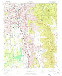 1975 Huntsville1976 Print · USGSHuntsville and the Tennessee Valley are seen here in the mid-seventies during a season of suburban expansion and industrial growth. Genealogists and historians can trace family locations near Maple Hill Cem, the grounds of Redstone Arsenal, and the old Merrimack Cem.3 unique versions available
 - 1975 Map of Greenbrier, 1977 Print
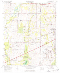 1975 Greenbrier1977 Print · USGSLimestone and Madison Counties are captured here in the mid-seventies as the area transitioned from a rail-and-gin economy toward modern aviation and urban growth. Genealogists can locate family landmarks like Ragland Cem, Burgreen Gin, and the historic West Madison Sch.3 unique versions available
 - 1975 Map of Madison, 1977 Print
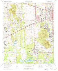 1975 Madison1977 Print · USGSMadison and Huntsville were undergoing significant expansion during the mid-seventies as aerospace technology reshaped the local economy. Genealogists and historians can trace the foundations of the University of Alabama in Huntsville or locate local burial grounds like Farley Cem and Moore Cem near the Redstone Arsenal.4 unique versions available
End of results
Showing maps 1-3 of 3
Top cities of Madison County
- Huntsville historical maps
- Meridianville historical maps
- Moores Mill historical maps
- Harvest historical maps
- Hazel Green historical maps
- Triana historical maps
See more
Frequently asked questions
- What are the different types of historical maps available for Madison County?
- What is the oldest map of Madison County?
- Where can I purchase historical maps of Madison County for my home or office?
- Where can I download high-res historical maps of Madison County?
- Are there historical topographic maps available for Madison County?
- Is there historical aerial imagery available for Madison County?
- Where are historical maps of Madison County sourced from?