1900s (20th Century) Maps of Old Town Historic District, Huntsville
Explore 10 historic maps of Old Town Historic District from the 1900s (20th Century). These maps offer a rare glimpse into what life looked like during the 1900s — showing old roads, neighborhoods, homes, and landmarks that have changed or disappeared over time.
Whether you're researching your family's past, planning a metal detecting trip, or studying how Old Town Historic District's landscape evolved across the 1900s, these high-resolution maps are a powerful tool for exploring the history of this region.
- Focus on a specific era: All maps on this page are from the 1900s, giving you a focused view of this time period.
- See what’s changed: Compare century-old streets, trails, and buildings to today's modern landscape using overlays and satellite layers.
- Research with precision: Use these maps for genealogy, historical research, land use analysis, or educational projects.
- View, download, or print: Maps are fully viewable online in high resolution, and can be downloaded or printed for your own records.
Start exploring Old Town Historic District's history through authentic maps from the 1900s. This is your window into the past.
Old Town Historic District, Huntsville maps
(10)- 1936 Map of Huntsville
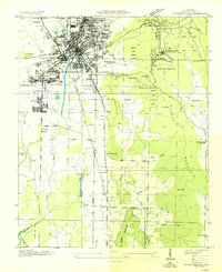 1936 Huntsville1936 Print · USGSHuntsville was a bustling railway and textile hub in the mid-thirties, just before the arrival of the space industry. Genealogists and historians can trace the footprint of early mill villages like Merrimac or locate family plots at Maple Hill Cem and Sivley Cem.
 - 1948 Map of Huntsville, 1956 Print
 1948 Huntsville1956 Print · USGSHuntsville at the start of its postwar boom reveals a landscape of industrial mill villages and quiet mountain coves. Researchers can trace the original Redstone Arsenal boundary or locate family sites at Maple Hill Cem and Mt Lebanon Ch.
 - 1950 Map of Huntsville
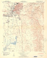 1950 Huntsville1950 Print · USGSHuntsville at the start of the 1950s shows the historic city center just as the military and aerospace sectors began to reshape the Tennessee Valley. Researchers can trace the massive Huntsville Arsenal boundaries, find early schools like Rison Sch, and locate family names at Merrimack Cem or Sivley Cem.2 unique versions available
 - 1956 Map of Gadsden, 1966 Print
 1956 Gadsden1966 Print · USGSNorth Alabama in the mid-1950s shows a region transformed by river engineering and federal industry. Genealogists and local historians can trace the development of the Tennessee Valley through the growth of Huntsville, the sprawling Redstone Arsenal, and the expansive Guntersville Lake.3 unique versions available
 - 1958 Map of Gadsden
 1958 Gadsden1958 Print · USGSNorth Alabama comes alive in the late 1950s as the Tennessee Valley Authority’s massive river projects and the rise of the space industry reshaped the landscape. Researchers can trace the mid-century footprints of Huntsville, Redstone Arsenal, and the riverside rail networks of the Southern railroad.
 - 1960 Map of Gadsden
 1960 Gadsden1960 Print · USGSNorthern Alabama in the mid-1950s is defined by the mighty Tennessee River and its massive reservoirs. Trace the development of Huntsville and Redstone Arsenal or explore the vast William B Bankhead National Forest.2 unique versions available
 - 1963 Map of Gadsden
 1963 Gadsden1963 Print · USGSNorthern Alabama underwent a dramatic mid-century transformation as the Tennessee Valley became a hub for defense and industry. Researchers can trace the development of the Redstone Arsenal, the route of the Natchez Trace Parkway, and long-standing rail lines like the Southern Railway.
 - 1964 Map of Huntsville, 1966 Print
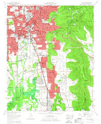 1964 Huntsville1966 Print · USGSHuntsville in the mid-sixties shows a city rapidly expanding south and east as suburban neighborhoods reach into the valleys. Genealogists can locate family sites near Maple Hill Cem, the Old Huntsville-Madison County Airport, and First Church.
 - 1975 Map of Huntsville, 1976 Print
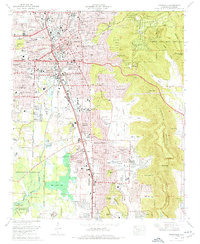 1975 Huntsville1976 Print · USGSHuntsville and the Tennessee Valley are seen here in the mid-seventies during a season of suburban expansion and industrial growth. Genealogists and historians can trace family locations near Maple Hill Cem, the grounds of Redstone Arsenal, and the old Merrimack Cem.3 unique versions available
 - 1984 Map of Huntsville, 1986 Print
 1984 Huntsville1986 Print · USGSNorthern Alabama and the Tennessee borderlands are captured in the mid-eighties as Huntsville and the Redstone Arsenal expand. Researchers can trace rural landmarks from Woodlin Mill to the Cumberland Plateau and old rail lines like the Southern.3 unique versions available
End of results
Showing maps 1-10 of 10
Frequently asked questions
- What are the different types of historical maps available for Old Town Historic District?
- What is the oldest map of Old Town Historic District?
- Where can I purchase historical maps of Old Town Historic District for my home or office?
- Where can I download high-res historical maps of Old Town Historic District?
- Are there historical topographic maps available for Old Town Historic District?
- Is there historical aerial imagery available for Old Town Historic District?
- Where are historical maps of Old Town Historic District sourced from?