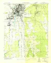
1936 Map of Huntsville
USGS Topo · Published 1936About this map
The Tennessee Valley Authority and U.S. Geological Survey collaborated on this 1930s study of Huntsville, showing a textile and railroad-focused city before its mid-century industrial expansion. The urban core is defined by the Nashville Chattanooga and St Louis Railway and the Southern Railway, which serviced outlying mill settlements like Merrimac and West Huntsville. Beyond the city grid, the landscape rises sharply into Huntsville Mountain, where the newly established Monte Sano State Park includes a Water Tank and several CCC Camps.
Find a feature on this map
49 named features on this map. Tap any name to fly to it.
Don’t see what you’re looking for? This feature index may not catch every label — zoom into the map to look around manually.
Map Details
Editions of this 1936 Huntsville Map
This is the sole edition of this map. No revisions or reprints were ever made.
Other maps of this area

1888 · Scottsboro
USGS Topo · 1:125,000

1888 · Huntsville
USGS Topo · 1:125,000

1892 · Huntsville
USGS Topo · 1:125,000

1892 · Scottsboro
USGS Topo · 1:125,000

1936 · Jeff
USGS Topo · 1:24,000

1936 · Triana
USGS Topo · 1:24,000

1936 · New Hope
USGS Topo · 1:24,000

1936 · Madison
USGS Topo · 1:24,000

1936 · Meridianville
USGS Topo · 1:24,000

1936 · Moontown
USGS Topo · 1:24,000