
1936 Map of Meridianville
USGS Topo · Published 1936About this map
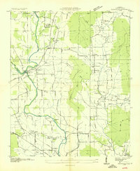
Alabama Agricultural and Mechanical Institute anchors the southern portion of this mid-1930s landscape, serving as a prominent educational landmark near the community of Normal. The map reveals a rural economy shaped by a dense network of country schools and family-named landmarks, such as Moores Mill and the Strawder Cem. A significant concentration of small educational facilities like Penny Sch, Cedar Glade Sch, and Mt Lebanon Sch indicates the localized nature of community life before the consolidation of rural school districts.
Find a feature on this map
49 named features on this map. Tap any name to fly to it.
Don’t see what you’re looking for? This feature index may not catch every label — zoom into the map to look around manually.
Map Details
Editions of this 1936 Meridianville Map
This is the sole edition of this map. No revisions or reprints were ever made.
Other maps of this area

1888 · Scottsboro
USGS Topo · 1:125,000

1888 · Huntsville
USGS Topo · 1:125,000

1892 · Huntsville
USGS Topo · 1:125,000

1892 · Scottsboro
USGS Topo · 1:125,000

1936 · Jeff
USGS Topo · 1:24,000

1936 · Madison
USGS Topo · 1:24,000

1936 · Moontown
USGS Topo · 1:24,000

1936 · Fisk
USGS Topo · 1:24,000

1936 · Toney
USGS Topo · 1:24,000
1936 · Maysville
USGS Topo · 1:24,000