1951 Map of Meridianville
USGS Topo · Published 1951About this map
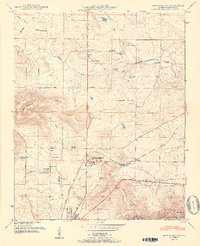
Alabama Agricultural and Mechanical Institute and its surrounding academic grounds serve as a central hub in this Madison County landscape, situated just north of the growing settlement at Lincoln. The terrain is defined by the sharp rise of Wade Mountain and Chapman Mountain, which hem in the agricultural flats where Meridianville was established. This mid-century survey reveals a dense network of rural infrastructure, from the Moores Mill landmark on the Flint River to the numerous small schools and churches like Taylor Chapel and Council Sch that supported local farm families. Transport is anchored by the Nashville Chattanooga and St Louis railway and the Florida Short Route, while the northern reaches show specialized land use such as the Water cress ponds along the Brier Fork Flint River.
Find a feature on this map
58 named features on this map. Tap any name to fly to it.
Don’t see what you’re looking for? This feature index may not catch every label — zoom into the map to look around manually.
Map Details
Editions of this 1951 Meridianville Map
2 editions found
Other maps of this area

1888 · Scottsboro
USGS Topo · 1:125,000

1888 · Huntsville
USGS Topo · 1:125,000

1892 · Huntsville
USGS Topo · 1:125,000

1892 · Scottsboro
USGS Topo · 1:125,000

1936 · Jeff
USGS Topo · 1:24,000

1936 · Madison
USGS Topo · 1:24,000

1936 · Meridianville
USGS Topo · 1:24,000

1936 · Moontown
USGS Topo · 1:24,000

1936 · Fisk
USGS Topo · 1:24,000

1936 · Toney
USGS Topo · 1:24,000