1951 Map of Meridianville
USGS Topo · Published 1951About this map
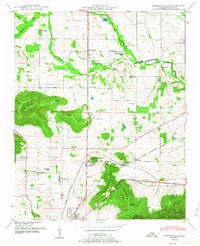
Meridianville anchors a landscape of small farming communities and educational institutions just north of the growing Huntsville area in the early 1950s. The northern reaches of the Alabama Agricultural and Mechanical Institute and its nearby Filtration bed signify the era's institutional development, while the Nashville Chattanooga and St Louis railway and the Florida Short Route facilitate regional movement. Local industry and agriculture are evident at Moores Mill and the specialized Water cress ponds along the Brier Fork Flint River. Significant topographical landmarks like Wade Mountain, Smith Mountain, and the Devils Race Track rise above the surrounding flats, providing a distinct backdrop to a network of family-named cemeteries and rural schools such as the Meridianville Bottom School and Penny Sch.
Find a feature on this map
60 named features on this map. Tap any name to fly to it.
Don’t see what you’re looking for? This feature index may not catch every label — zoom into the map to look around manually.
Map Details
Editions of this 1951 Meridianville Map
2 editions found
Other maps of this area

1888 · Scottsboro
USGS Topo · 1:125,000

1888 · Huntsville
USGS Topo · 1:125,000

1892 · Huntsville
USGS Topo · 1:125,000

1892 · Scottsboro
USGS Topo · 1:125,000

1936 · Jeff
USGS Topo · 1:24,000

1936 · Madison
USGS Topo · 1:24,000

1936 · Meridianville
USGS Topo · 1:24,000

1936 · Moontown
USGS Topo · 1:24,000

1936 · Fisk
USGS Topo · 1:24,000

1936 · Toney
USGS Topo · 1:24,000