
1936 Map of Madison
USGS Topo · Published 1936About this map
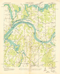
Madison anchors the western edge of this 1930s landscape, positioned along the Southern railroad at a time when the region's rural character was being reshaped by large-scale infrastructure. The Tennessee Valley Authority's influence is evident in the newly defined Wheeler Reservoir and its associated Wheeler Reservoir Boundary to the south. This survey captures a dense network of country institutions, including Hickory Grove School, Fuller Chapel, and Center Grove Church, which served the farming families of Madison County.
Find a feature on this map
42 named features on this map. Tap any name to fly to it.
Don’t see what you’re looking for? This feature index may not catch every label — zoom into the map to look around manually.
Map Details
Editions of this 1936 Madison Map
This is the sole edition of this map. No revisions or reprints were ever made.
Other maps of this area

1888 · Huntsville
USGS Topo · 1:125,000

1892 · Huntsville
USGS Topo · 1:125,000

1936 · Jeff
USGS Topo · 1:24,000

1936 · Capshaw
USGS Topo · 1:24,000
1936 · Triana
USGS Topo · 1:24,000

1936 · Meridianville
USGS Topo · 1:24,000

1936 · Mason Ridge
USGS Topo · 1:24,000

1936 · Greenbrier
USGS Topo · 1:24,000

1936 · Farley
USGS Topo · 1:24,000
1936 · Huntsville
USGS Topo · 1:24,000