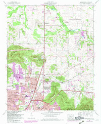
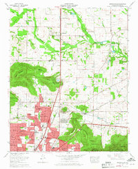
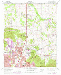
1964 Map of Meridianville
USGS Topo · Published 1982About this map
Meridianville and the northern outskirts of Huntsville anchor this landscape during a period of significant suburban and institutional expansion. The northern reaches are characterized by agricultural foundations and water-intensive commerce, evidenced by the numerous water cress ponds along Brier Fork Flint River. To the south, the presence of the Alabama Agricultural and Mechanical College and several technical schools indicates an era of educational development. The terrain is defined by prominent rises like Wade Mountain and Smithers Mountain, where the Devils Race Track and various springs punctuate the slopes. Transportation corridors such as the Florida Short Route and the Louisville and Nashville RR facilitate movement between rural settlements and the growing city center. Numerous small cemeteries like Pope Cem and Humphrey Cem offer valuable points of interest for genealogists tracing local families in Madison County.
Find a feature on this map
88 named features on this map. Tap any name to fly to it.
Don’t see what you’re looking for? This feature index may not catch every label — zoom into the map to look around manually.
Map Details
Editions of this 1964 Meridianville Map
Other maps of this area

1888 · Scottsboro
USGS Topo · 1:125,000

1888 · Huntsville
USGS Topo · 1:125,000

1892 · Huntsville
USGS Topo · 1:125,000

1892 · Scottsboro
USGS Topo · 1:125,000

1936 · Jeff
USGS Topo · 1:24,000

1936 · Madison
USGS Topo · 1:24,000

1936 · Meridianville
USGS Topo · 1:24,000

1936 · Moontown
USGS Topo · 1:24,000

1936 · Fisk
USGS Topo · 1:24,000

1936 · Toney
USGS Topo · 1:24,000