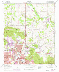
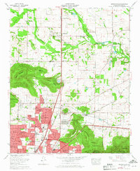
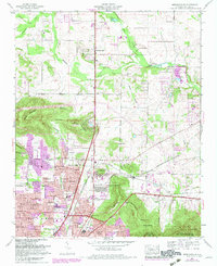
1964 Map of Meridianville
USGS Topo · Published 1976About this map
Meridianville and its surrounding agricultural landscape dominate this mid-century survey, which reveals a transition from traditional farming toward the suburban expansion of northern Huntsville. The terrain is defined by the winding course of Beaverdam Creek and the Brier Fork Flint River, with specialized land use evident in the Water cress ponds near the center of the sheet. Notable landmarks of the era include the campus of the Alabama Agricultural and Mechanical College and the industrial presence of Moores Mill.
Find a feature on this map
77 named features on this map. Tap any name to fly to it.
Don’t see what you’re looking for? This feature index may not catch every label — zoom into the map to look around manually.
Map Details
Editions of this 1964 Meridianville Map
Other maps of this area

1888 · Scottsboro
USGS Topo · 1:125,000

1888 · Huntsville
USGS Topo · 1:125,000

1892 · Huntsville
USGS Topo · 1:125,000

1892 · Scottsboro
USGS Topo · 1:125,000

1936 · Jeff
USGS Topo · 1:24,000

1936 · Madison
USGS Topo · 1:24,000

1936 · Meridianville
USGS Topo · 1:24,000

1936 · Moontown
USGS Topo · 1:24,000

1936 · Fisk
USGS Topo · 1:24,000

1936 · Toney
USGS Topo · 1:24,000