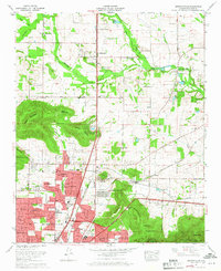
1964 Map of Meridianville
USGS Topo · Published 1968About this map
Meridianville and the northern outskirts of Huntsville appear here during a period of significant mid-century suburban expansion. The map is defined by the prominent heights of Wade Mountain and Smithers Mountain, which separate the flat farmland to the north from the growing residential developments of Meadow Hills and Edmonton Heights. A key institutional landmark is the Alabama Agricultural and Mechanical College, situated near the base of Chapman Mountain. The era's transportation infrastructure is well-documented, featuring the Louisville and Nashville railroad line and the Florida Short Route. Cultural and recreational life of the 1960s is evidenced by the Valley View Golf Course and a drive-in theater located along the southern highway corridor. Numerous rural landmarks, including the Antioch Ch and Strong Cem, remain preserved amidst the changing landscape.
Find a feature on this map
79 named features on this map. Tap any name to fly to it.
Don’t see what you’re looking for? This feature index may not catch every label — zoom into the map to look around manually.
Map Details
Editions of this 1964 Meridianville Map
Other maps of this area

1888 · Scottsboro
USGS Topo · 1:125,000

1888 · Huntsville
USGS Topo · 1:125,000

1892 · Huntsville
USGS Topo · 1:125,000

1892 · Scottsboro
USGS Topo · 1:125,000

1936 · Jeff
USGS Topo · 1:24,000

1936 · Madison
USGS Topo · 1:24,000

1936 · Meridianville
USGS Topo · 1:24,000

1936 · Moontown
USGS Topo · 1:24,000

1936 · Fisk
USGS Topo · 1:24,000

1936 · Toney
USGS Topo · 1:24,000