1960s Maps of Guin, Alabama
Explore 6 historic maps of Guin from the 1960s. These maps offer a rare glimpse into what life looked like during the 1960s — showing old roads, neighborhoods, homes, and landmarks that have changed or disappeared over time.
Whether you're researching your family's past, planning a metal detecting trip, or studying how Guin's landscape evolved across the 1960s, these high-resolution maps are a powerful tool for exploring the history of this region.
- Focus on a specific era: All maps on this page are from the 1960s, giving you a focused view of this time period.
- See what’s changed: Compare century-old streets, trails, and buildings to today's modern landscape using overlays and satellite layers.
- Research with precision: Use these maps for genealogy, historical research, land use analysis, or educational projects.
- View, download, or print: Maps are fully viewable online in high resolution, and can be downloaded or printed for your own records.
Start exploring Guin's history through authentic maps from the 1960s. This is your window into the past.
Guin, AL maps
(6)- 1960 Map of Gadsden
 1960 Gadsden1960 Print · USGSNorthern Alabama in the mid-1950s is defined by the mighty Tennessee River and its massive reservoirs. Trace the development of Huntsville and Redstone Arsenal or explore the vast William B Bankhead National Forest.2 unique versions available
 - 1963 Map of Gadsden
 1963 Gadsden1963 Print · USGSNorthern Alabama underwent a dramatic mid-century transformation as the Tennessee Valley became a hub for defense and industry. Researchers can trace the development of the Redstone Arsenal, the route of the Natchez Trace Parkway, and long-standing rail lines like the Southern Railway.
 - 1967 Map of Brilliant, 1968 Print
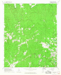 1967 Brilliant1968 Print · USGSMarion County's coal and rail landscape comes into focus in the late sixties, centered on the mining operations around Brilliant. Researchers can trace old family sites and rural landmarks like Yampertown, Pearces Mills, and Mt Joy Cem.3 unique versions available
 - 1967 Map of Hamilton SW, 1968 Print
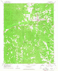
 1967 Hamilton SW1968 Print · USGSMarion County during the late sixties is depicted here as a landscape of small settlements and emerging infrastructure. Genealogists and local historians can trace the locations of family landmarks like Donham Cem, Liberty Ch, and the community of Pikeville.2 unique versions available
 - 1967 Map of Winfield, 1968 Print
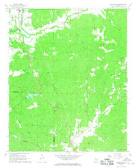
 1967 Winfield1968 Print · USGSMarion and Fayette counties are shown here in the late sixties as the town of Winfield expands along the railroad. Local researchers can trace family landmarks like Musgrove Chapel, the Drive-in Theater, and the old mining Airshaft.3 unique versions available
 - 1967 Map of Guin, 1968 Print
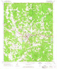
 1967 Guin1968 Print · USGSMarion County hill country centers on the town of Guin during the late sixties as the local economy balances rail transport and gravel mining. Researchers can trace rural lineages through numerous sites like Mount Olive Cem, Love Joy Ch, and Piney Grove Ch.
End of results
Showing maps 1-6 of 6
Top cities near Guin
- Hamilton historical maps
- Winfield historical maps
- Haleyville historical maps
- Vernon historical maps
- Sulligent historical maps
- Brilliant historical maps
See more
Frequently asked questions
- What are the different types of historical maps available for Guin?
- What is the oldest map of Guin?
- Where can I purchase historical maps of Guin for my home or office?
- Where can I download high-res historical maps of Guin?
- Are there historical topographic maps available for Guin?
- Is there historical aerial imagery available for Guin?
- Where are historical maps of Guin sourced from?