1930s Maps of Albertville, Alabama
Explore 4 historic maps of Albertville from the 1930s. These maps offer a rare glimpse into what life looked like during the 1930s — showing old roads, neighborhoods, homes, and landmarks that have changed or disappeared over time.
Whether you're researching your family's past, planning a metal detecting trip, or studying how Albertville's landscape evolved across the 1930s, these high-resolution maps are a powerful tool for exploring the history of this region.
- Focus on a specific era: All maps on this page are from the 1930s, giving you a focused view of this time period.
- See what’s changed: Compare century-old streets, trails, and buildings to today's modern landscape using overlays and satellite layers.
- Research with precision: Use these maps for genealogy, historical research, land use analysis, or educational projects.
- View, download, or print: Maps are fully viewable online in high resolution, and can be downloaded or printed for your own records.
Start exploring Albertville's history through authentic maps from the 1930s. This is your window into the past.
Albertville, AL maps
(4)- 1936 Map of Guntersville
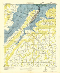 1936 Guntersville1936 Print · USGSGuntersville and the Tennessee River valley are shown here in the mid-thirties during the early stages of reservoir flooding. Researchers can trace the river's transformation near Smith Landing Field or locate rural landmarks like Lattiswood Sch and Warrenton Ch.
 - 1936 Map of Mountainboro
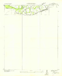
 1936 Mountainboro1936 Print · USGSThe Marshall and Etowah County borderlands are captured here in the mid-1930s, defined by the crossing of the Old Cherokee Boundary. You can trace the rural infrastructure of the day, from the Bethsaida Sch to the Nashville Chattanooga and St Louis railroad.
 - 1936 Map of High Point
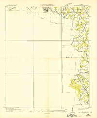
 1936 High Point1936 Print · USGSMarshall County's upland plateau is captured in the mid-1930s during a period of significant Tennessee Valley Authority activity. Genealogists and local historians can trace family locations near Hyatt, High Point, and the Rock Spring Ch along the heights of Sand Mountain.
 - 1936 Map of Albertville
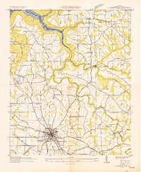 1936 Albertville1936 Print · USGSMarshall County's upland plateau is captured here during the mid-1930s as the Tennessee Valley Authority began transforming the landscape. Researchers can trace rural lineages through sites like Martling Cem, Alder Springs, and Brashier Chapel Sch.
End of results
Showing maps 1-4 of 4
Top cities near Albertville
- Gadsden historical maps
- Boaz historical maps
- Guntersville historical maps
- Whitesboro historical maps
- Crossville historical maps
- Sardis City historical maps
See more
Top neighborhoods of Albertville
Frequently asked questions
- What are the different types of historical maps available for Albertville?
- What is the oldest map of Albertville?
- Where can I purchase historical maps of Albertville for my home or office?
- Where can I download high-res historical maps of Albertville?
- Are there historical topographic maps available for Albertville?
- Is there historical aerial imagery available for Albertville?
- Where are historical maps of Albertville sourced from?