1970s Maps of Albertville, Alabama
Explore 2 historic maps of Albertville from the 1970s. These maps offer a rare glimpse into what life looked like during the 1970s — showing old roads, neighborhoods, homes, and landmarks that have changed or disappeared over time.
Whether you're researching your family's past, planning a metal detecting trip, or studying how Albertville's landscape evolved across the 1970s, these high-resolution maps are a powerful tool for exploring the history of this region.
- Focus on a specific era: All maps on this page are from the 1970s, giving you a focused view of this time period.
- See what’s changed: Compare century-old streets, trails, and buildings to today's modern landscape using overlays and satellite layers.
- Research with precision: Use these maps for genealogy, historical research, land use analysis, or educational projects.
- View, download, or print: Maps are fully viewable online in high resolution, and can be downloaded or printed for your own records.
Start exploring Albertville's history through authentic maps from the 1970s. This is your window into the past.
Albertville, AL maps
(2)- 1975 Map of Douglas, 1977 Print
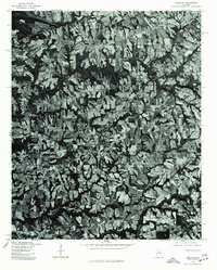 1975 Douglas1977 Print · USGSNorthern Alabama in the mid-seventies is captured here through detailed aerial imagery of the Marshall County countryside. Genealogists and local historians can trace field boundaries and home sites around the settlements of Douglas, Horton, and Hyatt.
 - 1976 Map of Boaz, 1977 Print
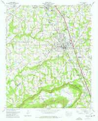 1976 Boaz1977 Print · USGSBoaz and Albertville were thriving railroad and educational centers on Sand Mountain in the mid-seventies. Researchers can locate family landmarks like Snead College, Murphree Crossroads, and the historic Old Mt Vernon Cem.3 unique versions available
End of results
Showing maps 1-2 of 2
Top cities near Albertville
- Gadsden historical maps
- Boaz historical maps
- Guntersville historical maps
- Whitesboro historical maps
- Crossville historical maps
- Sardis City historical maps
See more
Top neighborhoods of Albertville
Frequently asked questions
- What are the different types of historical maps available for Albertville?
- What is the oldest map of Albertville?
- Where can I purchase historical maps of Albertville for my home or office?
- Where can I download high-res historical maps of Albertville?
- Are there historical topographic maps available for Albertville?
- Is there historical aerial imagery available for Albertville?
- Where are historical maps of Albertville sourced from?