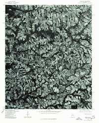
1975 Map of Douglas
USGS Topo · Published 1977About this map
The agricultural landscape of Marshall County is revealed in this 1975 orthophotoquad, which captures the intricate field patterns and wooded drainages of the Douglas area. This specific map, produced by the Department of the Interior in cooperation with the Soil Conservation Service, uses aerial photography to document the mid-1970s rural layout of the region. Unlike standard topographic maps, this imagery-based study shows the actual land use and vegetation density surrounding the crossroads of Horton and the small settlement of Hyatt. It provides an authentic look at the patchwork of farmland and forest that defined this part of Alabama before late-century development altered the local topography. Researchers can clearly see the concentration of structures along the primary road networks and the way the natural creek beds dictated the shapes of the surrounding fields.
Find a feature on this map
3 named features on this map. Tap any name to fly to it.
Don’t see what you’re looking for? This feature index may not catch every label — zoom into the map to look around manually.
Map Details
Editions of this 1975 Douglas Map
This is the sole edition of this map. No revisions or reprints were ever made.
Other maps of this area

1885 · Gadsden
USGS Topo · 1:125,000

1888 · Gadsden
USGS Topo · 1:125,000

1892 · Gadsden
USGS Topo · 1:125,000

1895 · Gadsden
USGS Topo · 1:125,000

1903 · Gadsden
USGS Topo · 1:125,000

1936 · Guntersville
USGS Topo · 1:24,000

1936 · Mountainboro
USGS Topo · 1:24,000

1936 · Arab
USGS Topo · 1:24,000
1936 · Brooksville
USGS Topo · 1:24,000

1936 · High Point
USGS Topo · 1:24,000