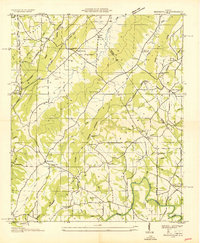
1936 Map of Brooksville
USGS Topo · Published 1936About this map
The Marshall Blount County Line bisects this 1936 survey, which highlights the agrarian landscape between Brindlee Mountain and Sand Mountain. Small communities such as Brooksville, Summit, and Nixon Chapel are connected by a network of early roads, including the Old Tennessee State Highway No 38 and the Old Cherokee Road. The Cherokee Basin dominates the central terrain, where local life centered around numerous country institutions like the Oak Hill Sch and Pleasant Hill Ch.
Find a feature on this map
50 named features on this map. Tap any name to fly to it.
Don’t see what you’re looking for? This feature index may not catch every label — zoom into the map to look around manually.
Map Details
Editions of this 1936 Brooksville Map
This is the sole edition of this map. No revisions or reprints were ever made.
Other maps of this area

1885 · Gadsden
USGS Topo · 1:125,000

1888 · Cullman
USGS Topo · 1:125,000

1888 · Gadsden
USGS Topo · 1:125,000

1892 · Cullman
USGS Topo · 1:125,000

1892 · Gadsden
USGS Topo · 1:125,000

1895 · Gadsden
USGS Topo · 1:125,000

1903 · Gadsden
USGS Topo · 1:125,000

1936 · Guntersville
USGS Topo · 1:24,000

1936 · Hulaco
USGS Topo · 1:24,000

1936 · Arab
USGS Topo · 1:24,000