
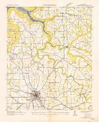
1936 Map of Mountainboro
USGS Topo · Published 1936About this map
Mountainboro and Saratoga anchor this 1936 survey of the Alabama uplands, where the landscape is fundamentally shaped by the Tennessee Basin Divide. The map details a period of transition as infrastructure projects like the Alabama Power Company Trans Line cut across the traditional terrain. A significant historical marker is the Old Cherokee Boundary, which traces a diagonal line across the quadrangle, reflecting the region's complex history of land division and settlement. The Nashville Chattanooga and St Louis railway runs parallel to State Route No 1, connecting rural hubs like Carlisle to the broader regional economy. Small-scale landmarks such as the Bethsaida Sch and a prominent Water Tank provide specific points of interest for genealogists tracing family roots near Wolf Creek and Norris Creek.
Find a feature on this map
23 named features on this map. Tap any name to fly to it.
Don’t see what you’re looking for? This feature index may not catch every label — zoom into the map to look around manually.
Map Details
Editions of this 1936 Mountainboro Map
This is the sole edition of this map. No revisions or reprints were ever made.
Other maps of this area

1885 · Gadsden
USGS Topo · 1:125,000

1888 · Gadsden
USGS Topo · 1:125,000

1892 · Gadsden
USGS Topo · 1:125,000

1895 · Gadsden
USGS Topo · 1:125,000

1903 · Gadsden
USGS Topo · 1:125,000

1936 · Painter
USGS Topo · 1:24,000

1936 · Guntersville
USGS Topo · 1:24,000

1936 · Rodentown
USGS Topo · 1:24,000

1936 · High Point
USGS Topo · 1:24,000
1936 · Albertville
USGS Topo · 1:24,000