1940s Maps of Albertville, Alabama
Explore 2 historic maps of Albertville from the 1940s. These maps offer a rare glimpse into what life looked like during the 1940s — showing old roads, neighborhoods, homes, and landmarks that have changed or disappeared over time.
Whether you're researching your family's past, planning a metal detecting trip, or studying how Albertville's landscape evolved across the 1940s, these high-resolution maps are a powerful tool for exploring the history of this region.
- Focus on a specific era: All maps on this page are from the 1940s, giving you a focused view of this time period.
- See what’s changed: Compare century-old streets, trails, and buildings to today's modern landscape using overlays and satellite layers.
- Research with precision: Use these maps for genealogy, historical research, land use analysis, or educational projects.
- View, download, or print: Maps are fully viewable online in high resolution, and can be downloaded or printed for your own records.
Start exploring Albertville's history through authentic maps from the 1940s. This is your window into the past.
Albertville, AL maps
(2)- 1947 Map of Albertville, 1965 Print
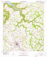 1947 Albertville1965 Print · USGSMarshall County's plateau and the southern reaches of Guntersville Lake come into focus just after the war. Local historians can trace the rail-and-road economy through the Nashville Chattanooga and St Louis Railway and landmarks like Rice Mill Bridge and Ephesus Ch.4 unique versions available
 - 1948 Map of Guntersville, 1969 Print
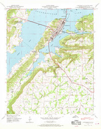 1948 Guntersville1969 Print · USGSMarshall County in the late 1940s reveals a region defined by the waters of Guntersville Lake and its busy river crossings. Genealogists can trace family names at Warrenton Cem or locate community hubs like Crossroads School and the N C & St L Ry Ferry.3 unique versions available
End of results
Showing maps 1-2 of 2
Top cities near Albertville
- Gadsden historical maps
- Boaz historical maps
- Guntersville historical maps
- Whitesboro historical maps
- Crossville historical maps
- Sardis City historical maps
See more
Top neighborhoods of Albertville
Frequently asked questions
- What are the different types of historical maps available for Albertville?
- What is the oldest map of Albertville?
- Where can I purchase historical maps of Albertville for my home or office?
- Where can I download high-res historical maps of Albertville?
- Are there historical topographic maps available for Albertville?
- Is there historical aerial imagery available for Albertville?
- Where are historical maps of Albertville sourced from?