1970s Maps of Montgomery, Alabama
Explore 8 historic maps of Montgomery from the 1970s. These maps offer a rare glimpse into what life looked like during the 1970s — showing old roads, neighborhoods, homes, and landmarks that have changed or disappeared over time.
Whether you're researching your family's past, planning a metal detecting trip, or studying how Montgomery's landscape evolved across the 1970s, these high-resolution maps are a powerful tool for exploring the history of this region.
- Focus on a specific era: All maps on this page are from the 1970s, giving you a focused view of this time period.
- See what’s changed: Compare century-old streets, trails, and buildings to today's modern landscape using overlays and satellite layers.
- Research with precision: Use these maps for genealogy, historical research, land use analysis, or educational projects.
- View, download, or print: Maps are fully viewable online in high resolution, and can be downloaded or printed for your own records.
Start exploring Montgomery's history through authentic maps from the 1970s. This is your window into the past.
Montgomery, AL maps
(8)- 1975 Map of Mount Meigs SE, 1977 Print
 1975 Mount Meigs SE1977 Print · USGSThe rural landscape east of Montgomery is captured in high detail in the mid-1970s, showcasing the agricultural patterns of central Alabama. Researchers can trace the exact footprints of settlements like Mount Meigs, Pike Road, and Waugh across the varied terrain.
 - 1975 Map of Mount Meigs NW, 1977 Print
 1975 Mount Meigs NW1977 Print · USGSEast of the state capital in the mid-1970s, this aerial study captures the winding bends of the Tallapoosa River. Local historians can trace the footprint of early development in Montgomery and the rural layout of Madison.
 - 1975 Map of Mount Meigs SW, 1977 Print
 1975 Mount Meigs SW1977 Print · USGSThe rural landscape east of Montgomery appears in this mid-1970s aerial survey just as highway development began to reshape the region. Researchers can trace land use patterns and property lines near the Interstate 85 corridor and surrounding agricultural tracts.
 - 1975 Map of Montgomery NW, 1977 Print
 1975 Montgomery NW1977 Print · USGSThe Alabama River corridor north of Montgomery shows a landscape of deep meanders and developing neighborhoods in the mid-seventies. Local historians can trace the intersection of rural land and new infrastructure along the banks of the Alabama River.
 - 1975 Map of Montgomery South, 1977 Print
 1975 Montgomery South1977 Print · USGSThe southern expansion of the Alabama capital is captured here during the mid-seventies, showing the urban edge meeting the countryside. Researchers can trace the development of Lynndale or locate early rural holdings near Hope Hull and the banks of Catoma Creek.
 - 1975 Map of Montgomery SW, 1977 Print
 1975 Montgomery SW1977 Print · USGSSouthwest of the state capital in the mid-seventies, this aerial view captures the rural-urban fringe as it transitioned from traditional farmland to modern infrastructure. Researchers can trace the winding course of the Alabama River and examine the intricate field patterns and roadways that defined the region at the time.
 - 1975 Map of Montgomery North, 1977 Print
 1975 Montgomery North1977 Print · USGSThe northern reaches of Montgomery and the winding Alabama River are shown in detail during the mid-1970s. Trace the development of local settlements like Boylston and Brook alongside the dramatic river meanders and growing road networks.
 - 1975 Map of Mount Meigs NE, 1977 Print
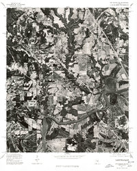
 1975 Mount Meigs NE1977 Print · USGSCovers Montgomery, including Pike Road, Emerald Mountain, and other nearby areas
End of results
Showing maps 1-8 of 8
Top cities near Montgomery
- Prattville historical maps
- Millbrook historical maps
- Pike Road historical maps
- Wetumpka historical maps
- Emerald Mountain historical maps
- Deatsville historical maps
See more
Top neighborhoods of Montgomery
- College Grove historical maps
- Perrys Mill historical maps
- Bellehurst historical maps
- Timbers historical maps
- Brewer Estates historical maps
- Bellwood Plantation historical maps
See more
Frequently asked questions
- What are the different types of historical maps available for Montgomery?
- What is the oldest map of Montgomery?
- Where can I purchase historical maps of Montgomery for my home or office?
- Where can I download high-res historical maps of Montgomery?
- Are there historical topographic maps available for Montgomery?
- Is there historical aerial imagery available for Montgomery?
- Where are historical maps of Montgomery sourced from?