1970s Maps of Cedron, Alabama
Explore 3 historic maps of Cedron from the 1970s. These maps offer a rare glimpse into what life looked like during the 1970s — showing old roads, neighborhoods, homes, and landmarks that have changed or disappeared over time.
Whether you're researching your family's past, planning a metal detecting trip, or studying how Cedron's landscape evolved across the 1970s, these high-resolution maps are a powerful tool for exploring the history of this region.
- Focus on a specific era: All maps on this page are from the 1970s, giving you a focused view of this time period.
- See what’s changed: Compare century-old streets, trails, and buildings to today's modern landscape using overlays and satellite layers.
- Research with precision: Use these maps for genealogy, historical research, land use analysis, or educational projects.
- View, download, or print: Maps are fully viewable online in high resolution, and can be downloaded or printed for your own records.
Start exploring Cedron's history through authentic maps from the 1970s. This is your window into the past.
Cedron, AL maps
(3)- 1970 Map of Micaville, 1973 Print
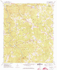 1970 Micaville1973 Print · USGSThe Alabama borderlands near the Tallapoosa River are captured here in the early seventies during a period of rural industry and local growth. Genealogists can trace family connections to the many rural churches and settlements like Micaville, Corinth, and Foster Crossroad.2 unique versions available
 - 1975 Map of Micaville, 1977 Print
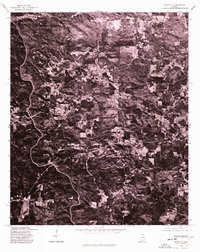 1975 Micaville1977 Print · USGSRandolph County in the mid-seventies appears in sharp detail through this specialized orthophotograph of the Alabama countryside. Local historians and land researchers can trace the rural junctions of Foster Crossroad, Fuller Crossroad, and the community at Micaville.
 - 1978 Map of La Grange, 1980 Print
 1978 La Grange1980 Print · USGSThe Alabama-Georgia borderlands are captured here in the late seventies, just as the newly formed West Point Lake reshaped the eastern landscape. Local historians can trace the Seaboard Coast Line rail corridor through hubs like Roanoke, Ashland, and Lineville.
End of results
Showing maps 1-3 of 3
Top cities near Cedron
- Oxford historical maps
- Heflin historical maps
- Tallapoosa historical maps
- Choccolocco historical maps
- Lineville historical maps
- Wedowee historical maps
See more
Frequently asked questions
- What are the different types of historical maps available for Cedron?
- What is the oldest map of Cedron?
- Where can I purchase historical maps of Cedron for my home or office?
- Where can I download high-res historical maps of Cedron?
- Are there historical topographic maps available for Cedron?
- Is there historical aerial imagery available for Cedron?
- Where are historical maps of Cedron sourced from?