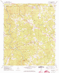
1970 Map of Micaville
USGS Topo · Published 1973About this map
Micaville and the winding course of the Tallapoosa River anchor this 1970s survey of the borderlands between Cleburne and Randolph counties. The landscape is defined by a dense network of country roads connecting small agricultural and rural communities such as Corinth, Wildwood, and Foster Crossroad. This era of the Alabama countryside shows a high concentration of community centers, notably a series of rural churches like Pine Tuckey Ch, Morrison Chapel, and Pilgrims Rest Ch. To the north, the presence of several Strip Mines suggests the industrial activities that shaped the local economy alongside traditional farming. Further south, the terrain rises toward Plunkett Mtn, while crossings like Lee Bridge and Foster Bridge provided essential access over the river, reflecting the local transportation patterns before more modern infrastructure changes.
Find a feature on this map
38 named features on this map. Tap any name to fly to it.
Don’t see what you’re looking for? This feature index may not catch every label — zoom into the map to look around manually.
Map Details
Editions of this 1970 Micaville Map
2 editions found
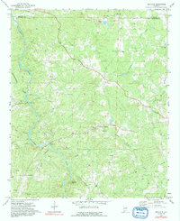
Other maps of this area

1889 · Tallapoosa
USGS Topo · 1:125,000

1891 · Ashland
USGS Topo · 1:125,000

1892 · Tallapoosa
USGS Topo · 1:125,000

1897 · Tallapoosa
USGS Topo · 1:125,000

1899 · Wedowee
USGS Topo · 1:125,000

1900 · Anniston
USGS Topo · 1:125,000

1902 · Wedowee
USGS Topo · 1:125,000

1953 · Atlanta
USGS Topo · 1:250,000

1957 · Atlanta
USGS Topo · 1:250,000

1958 · Atlanta
USGS Topo · 1:250,000