1900-1909 Maps of Calera, Alabama
Explore 1 historic maps of Calera from 1900-1909. These maps offer a rare glimpse into what life looked like during the 1900s — showing old roads, neighborhoods, homes, and landmarks that have changed or disappeared over time.
Whether you're researching your family's past, planning a metal detecting trip, or studying how Calera's landscape evolved across the 1900s, these high-resolution maps are a powerful tool for exploring the history of this region.
- Focus on a specific era: All maps on this page are from the 1900s, giving you a focused view of this time period.
- See what’s changed: Compare century-old streets, trails, and buildings to today's modern landscape using overlays and satellite layers.
- Research with precision: Use these maps for genealogy, historical research, land use analysis, or educational projects.
- View, download, or print: Maps are fully viewable online in high resolution, and can be downloaded or printed for your own records.
Start exploring Calera's history through authentic maps from the 1900s. This is your window into the past.
Calera, AL maps
(1)- 1909 Map of Columbiana, 1968 Print
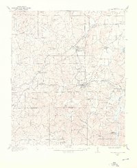 1909 Columbiana1968 Print · USGSShelby County at the start of the twentieth century was a vital junction for the Southern and L&N railroads. Local researchers can locate family landmarks like Watson Ford, several rural schools including Summer Hill School, and early churches like Lyon Church.
End of results
Showing maps 1-1 of 1
Top cities near Calera
- Hoover historical maps
- Alabaster historical maps
- Bessemer historical maps
- Pelham historical maps
- Helena historical maps
- Chelsea historical maps
See more
Top neighborhoods of Calera
- Shelby Springs historical maps
- Dargin historical maps
- Pasqua historical maps
- Townside Square historical maps
Frequently asked questions
- What are the different types of historical maps available for Calera?
- What is the oldest map of Calera?
- Where can I purchase historical maps of Calera for my home or office?
- Where can I download high-res historical maps of Calera?
- Are there historical topographic maps available for Calera?
- Is there historical aerial imagery available for Calera?
- Where are historical maps of Calera sourced from?