1970s Maps of Odenville, Alabama
Explore 3 historic maps of Odenville from the 1970s. These maps offer a rare glimpse into what life looked like during the 1970s — showing old roads, neighborhoods, homes, and landmarks that have changed or disappeared over time.
Whether you're researching your family's past, planning a metal detecting trip, or studying how Odenville's landscape evolved across the 1970s, these high-resolution maps are a powerful tool for exploring the history of this region.
- Focus on a specific era: All maps on this page are from the 1970s, giving you a focused view of this time period.
- See what’s changed: Compare century-old streets, trails, and buildings to today's modern landscape using overlays and satellite layers.
- Research with precision: Use these maps for genealogy, historical research, land use analysis, or educational projects.
- View, download, or print: Maps are fully viewable online in high resolution, and can be downloaded or printed for your own records.
Start exploring Odenville's history through authentic maps from the 1970s. This is your window into the past.
Odenville, AL maps
(3)- 1975 Map of Wattsville, 1977 Print
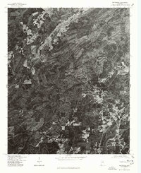 1975 Wattsville1977 Print · USGSCovers Odenville, including Pell City, Coal City, and other nearby areas
 - 1975 Map of Odenville, 1977 Print
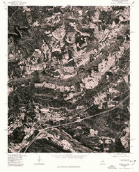
 1975 Odenville1977 Print · USGSOdenville and the surrounding St. Clair County landscape appear in crisp detail in this mid-seventies aerial survey. Researchers can trace the development of the road network and see the exact layout of land holdings around Odenville during this era.
 - 1975 Map of Springville, 1977 Print
 1975 Springville1977 Print · USGSSt. Clair County appears in high-contrast detail during the mid-seventies, showing the intersection of ridge-and-valley terrain with new infrastructure. Researchers can locate the historic community of Saint Clair Springs and trace the shoreline of INLAND LAKE.
End of results
Showing maps 1-3 of 3
Top cities near Odenville
- Birmingham historical maps
- Trussville historical maps
- Irondale historical maps
- Moody historical maps
- Pell City historical maps
- Leeds historical maps
See more
Top neighborhoods of Odenville
- Copper Springs historical maps
- Green Acres Estates historical maps
- Havilah Hills Estates historical maps
- Shady Acres historical maps
Frequently asked questions
- What are the different types of historical maps available for Odenville?
- What is the oldest map of Odenville?
- Where can I purchase historical maps of Odenville for my home or office?
- Where can I download high-res historical maps of Odenville?
- Are there historical topographic maps available for Odenville?
- Is there historical aerial imagery available for Odenville?
- Where are historical maps of Odenville sourced from?