1910s Maps of Talladega County, Alabama
Explore 3 historic maps of Talladega County from the 1910s. These maps offer a rare glimpse into what life looked like during the 1910s — showing old roads, neighborhoods, homes, and landmarks that have changed or disappeared over time.
Whether you're researching your family's past, planning a metal detecting trip, or studying how Talladega County's landscape evolved across the 1910s, these high-resolution maps are a powerful tool for exploring the history of this region.
- Focus on a specific era: All maps on this page are from the 1910s, giving you a focused view of this time period.
- See what’s changed: Compare century-old streets, trails, and buildings to today's modern landscape using overlays and satellite layers.
- Research with precision: Use these maps for genealogy, historical research, land use analysis, or educational projects.
- View, download, or print: Maps are fully viewable online in high resolution, and can be downloaded or printed for your own records.
Start exploring Talladega County's history through authentic maps from the 1910s. This is your window into the past.
Talladega County, AL maps
(3)- 1911 Map of Columbiana
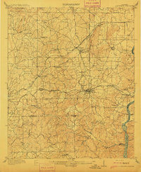 1911 Columbiana1911 Print · USGSCentral Alabama's industrial landscape is captured here just after the first decade of the century, showing a region deeply connected by rail and river. Genealogists can trace family names at Woods Ferry or locate old community hubs like Summer Hill School and Kingdom Church.2 unique versions available
 - 1915 Map of Gantts Quarry
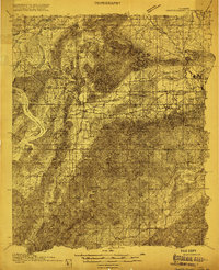 1915 Gantts Quarry1915 Print · USGSTalladega and Shelby counties appear here during the height of the early twentieth-century marble boom. Researchers can trace the rail-driven economy near Sylacauga and locate family landmarks like Oak Grove Church, Gantts Quarry, and Center Hill School.4 unique versions available
 - 1917 Map of Gantts Quarry
 1917 Gantts Quarry1917 Print · USGSThe marble-rich corridor between the Coosa River and Sylacauga is captured here during the height of the early twentieth-century quarrying boom. Researchers can trace the rail-and-river economy through landmarks like Gantts Quarry, Mc Gowan Ferry, and Eureka Quarry.3 unique versions available
End of results
Showing maps 1-3 of 3
Top cities of Talladega County
- Talladega historical maps
- Sylacauga historical maps
- Lincoln historical maps
- Childersburg historical maps
- Fayetteville historical maps
- Munford historical maps
See more
Frequently asked questions
- What are the different types of historical maps available for Talladega County?
- What is the oldest map of Talladega County?
- Where can I purchase historical maps of Talladega County for my home or office?
- Where can I download high-res historical maps of Talladega County?
- Are there historical topographic maps available for Talladega County?
- Is there historical aerial imagery available for Talladega County?
- Where are historical maps of Talladega County sourced from?