1970s Maps of Talladega, Alabama
Explore 2 historic maps of Talladega from the 1970s. These maps offer a rare glimpse into what life looked like during the 1970s — showing old roads, neighborhoods, homes, and landmarks that have changed or disappeared over time.
Whether you're researching your family's past, planning a metal detecting trip, or studying how Talladega's landscape evolved across the 1970s, these high-resolution maps are a powerful tool for exploring the history of this region.
- Focus on a specific era: All maps on this page are from the 1970s, giving you a focused view of this time period.
- See what’s changed: Compare century-old streets, trails, and buildings to today's modern landscape using overlays and satellite layers.
- Research with precision: Use these maps for genealogy, historical research, land use analysis, or educational projects.
- View, download, or print: Maps are fully viewable online in high resolution, and can be downloaded or printed for your own records.
Start exploring Talladega's history through authentic maps from the 1970s. This is your window into the past.
Talladega, AL maps
(2)- 1975 Map of Talladega NW, 1977 Print
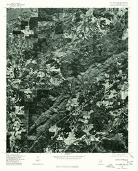 1975 Talladega NW1977 Print · USGSMid-1970s Alabama comes into focus in this aerial survey, capturing the industrial and riverine character of the Talladega area. Local researchers can trace the development of Bemiston and examine the banks of the Coosa River at this moment in time.
 - 1975 Map of Talladega NE, 1977 Print
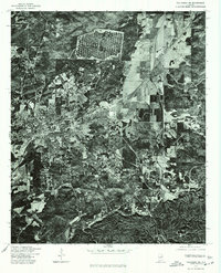 1975 Talladega NE1977 Print · USGSTalladega and its outlying communities are captured in clear aerial detail during the mid-seventies. Local historians and researchers can trace the development of the city streets in Talladega or locate the residential patterns of Bemiston and Waldo.
End of results
Showing maps 1-2 of 2
Top cities near Talladega
- Oxford historical maps
- Anniston historical maps
- Pell City historical maps
- Sylacauga historical maps
- Lincoln historical maps
- Childersburg historical maps
See more
Top neighborhoods of Talladega
- Sliocco Springs historical maps
- Shocco Springs historical maps
- Bemiston historical maps
- Thornhill historical maps
- Brecon historical maps
- Jonesville historical maps
See more
Frequently asked questions
- What are the different types of historical maps available for Talladega?
- What is the oldest map of Talladega?
- Where can I purchase historical maps of Talladega for my home or office?
- Where can I download high-res historical maps of Talladega?
- Are there historical topographic maps available for Talladega?
- Is there historical aerial imagery available for Talladega?
- Where are historical maps of Talladega sourced from?