1970s Maps of Dadeville, Alabama
Explore 2 historic maps of Dadeville from the 1970s. These maps offer a rare glimpse into what life looked like during the 1970s — showing old roads, neighborhoods, homes, and landmarks that have changed or disappeared over time.
Whether you're researching your family's past, planning a metal detecting trip, or studying how Dadeville's landscape evolved across the 1970s, these high-resolution maps are a powerful tool for exploring the history of this region.
- Focus on a specific era: All maps on this page are from the 1970s, giving you a focused view of this time period.
- See what’s changed: Compare century-old streets, trails, and buildings to today's modern landscape using overlays and satellite layers.
- Research with precision: Use these maps for genealogy, historical research, land use analysis, or educational projects.
- View, download, or print: Maps are fully viewable online in high resolution, and can be downloaded or printed for your own records.
Start exploring Dadeville's history through authentic maps from the 1970s. This is your window into the past.
Dadeville, AL maps
(2)- 1971 Map of Dadeville, 1973 Print
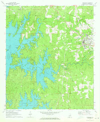 1971 Dadeville1973 Print · USGSTallapoosa County's landscape in the early 1970s is defined by the reaching waters of Martin Lake and the established rail lines of the Central of Georgia. Genealogists can locate family landmarks like Spain Cem and Williams Cem, or trace rural congregations at Mt Zion Ch and Sandy Creek Ch.3 unique versions available
 - 1971 Map of Camp Hill, 1973 Print
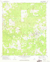 1971 Camp Hill1973 Print · USGSTallapoosa County in the early seventies reveals a landscape of established rail towns and historic academies. Genealogists and historians can trace family sites at Baskins Chapel Cem or locate the grounds of the Lyman Ward Military Academy.2 unique versions available
End of results
Showing maps 1-2 of 2
Top cities near Dadeville
- Auburn historical maps
- Alexander City historical maps
- Camp Hill historical maps
- New Site historical maps
- Jacksons' Gap historical maps
- Our Town historical maps
See more
Top neighborhoods of Dadeville
Frequently asked questions
- What are the different types of historical maps available for Dadeville?
- What is the oldest map of Dadeville?
- Where can I purchase historical maps of Dadeville for my home or office?
- Where can I download high-res historical maps of Dadeville?
- Are there historical topographic maps available for Dadeville?
- Is there historical aerial imagery available for Dadeville?
- Where are historical maps of Dadeville sourced from?