1970s Maps of Bradleytown, Alabama
Explore 2 historic maps of Bradleytown from the 1970s. These maps offer a rare glimpse into what life looked like during the 1970s — showing old roads, neighborhoods, homes, and landmarks that have changed or disappeared over time.
Whether you're researching your family's past, planning a metal detecting trip, or studying how Bradleytown's landscape evolved across the 1970s, these high-resolution maps are a powerful tool for exploring the history of this region.
- Focus on a specific era: All maps on this page are from the 1970s, giving you a focused view of this time period.
- See what’s changed: Compare century-old streets, trails, and buildings to today's modern landscape using overlays and satellite layers.
- Research with precision: Use these maps for genealogy, historical research, land use analysis, or educational projects.
- View, download, or print: Maps are fully viewable online in high resolution, and can be downloaded or printed for your own records.
Start exploring Bradleytown's history through authentic maps from the 1970s. This is your window into the past.
Bradleytown, AL maps
(2)- 1971 Map of Goodsprings, 1973 Print
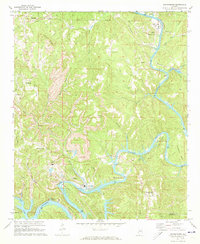 1971 Goodsprings1973 Print · USGSThe coal and power corridor of Walker County is on full display in the early 1970s, where the winding Mulberry Fork meets industrial growth. Genealogists and historians can locate the Martin High Sch, Busby Cem, and several Strip Mine sites near Gorgas.4 unique versions available
 - 1975 Map of Goodsprings, 1977 Print
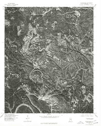 1975 Goodsprings1977 Print · USGSThe winding Black Warrior River and its surrounding coalfields dominate this mid-seventies aerial survey of Walker County. Genealogists and industrial historians can trace the residential layouts of Gorgas, Dovertown, and Aldridge amidst massive surface mines.
End of results
Showing maps 1-2 of 2
Top cities near Bradleytown
- Birmingham historical maps
- Jasper historical maps
- Adamsville historical maps
- Sumiton historical maps
- Dora historical maps
- Cordova historical maps
See more
Frequently asked questions
- What are the different types of historical maps available for Bradleytown?
- What is the oldest map of Bradleytown?
- Where can I purchase historical maps of Bradleytown for my home or office?
- Where can I download high-res historical maps of Bradleytown?
- Are there historical topographic maps available for Bradleytown?
- Is there historical aerial imagery available for Bradleytown?
- Where are historical maps of Bradleytown sourced from?