1930s Maps of Samoset, Alabama
Explore 2 historic maps of Samoset from the 1930s. These maps offer a rare glimpse into what life looked like during the 1930s — showing old roads, neighborhoods, homes, and landmarks that have changed or disappeared over time.
Whether you're researching your family's past, planning a metal detecting trip, or studying how Samoset's landscape evolved across the 1930s, these high-resolution maps are a powerful tool for exploring the history of this region.
- Focus on a specific era: All maps on this page are from the 1930s, giving you a focused view of this time period.
- See what’s changed: Compare century-old streets, trails, and buildings to today's modern landscape using overlays and satellite layers.
- Research with precision: Use these maps for genealogy, historical research, land use analysis, or educational projects.
- View, download, or print: Maps are fully viewable online in high resolution, and can be downloaded or printed for your own records.
Start exploring Samoset's history through authentic maps from the 1930s. This is your window into the past.
Samoset, AL maps
(2)- 1935 Map of Port Birmingham
 1935 Port Birmingham1935 Print · USGSThe coal and power corridor of the Black Warrior River is captured here in the mid-1930s, showing a landscape defined by mines and industrial camps. Genealogists can locate family sites at Pennsylvania Camp, Satterfield Cem, or the Barney Mine community.
 - 1938 Map of Port Birmingham
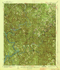 1938 Port Birmingham1938 Print · USGSThe river-and-rail industry of the Black Warrior coalfields is captured here in the late 1930s. Genealogists and historians can trace the foundations of local commerce at Port Birmingham and locate vanished river crossings like Underwood Ferry or the Atwood Ferry.4 unique versions available
End of results
Showing maps 1-2 of 2
Top cities near Samoset
- Birmingham historical maps
- Jasper historical maps
- Pleasant Grove historical maps
- Adamsville historical maps
- Sumiton historical maps
- Dora historical maps
See more
Frequently asked questions
- What are the different types of historical maps available for Samoset?
- What is the oldest map of Samoset?
- Where can I purchase historical maps of Samoset for my home or office?
- Where can I download high-res historical maps of Samoset?
- Are there historical topographic maps available for Samoset?
- Is there historical aerial imagery available for Samoset?
- Where are historical maps of Samoset sourced from?