1900s (20th Century) Maps of Sumiton, Alabama
Explore 11 historic maps of Sumiton from the 1900s (20th Century). These maps offer a rare glimpse into what life looked like during the 1900s — showing old roads, neighborhoods, homes, and landmarks that have changed or disappeared over time.
Whether you're researching your family's past, planning a metal detecting trip, or studying how Sumiton's landscape evolved across the 1900s, these high-resolution maps are a powerful tool for exploring the history of this region.
- Focus on a specific era: All maps on this page are from the 1900s, giving you a focused view of this time period.
- See what’s changed: Compare century-old streets, trails, and buildings to today's modern landscape using overlays and satellite layers.
- Research with precision: Use these maps for genealogy, historical research, land use analysis, or educational projects.
- View, download, or print: Maps are fully viewable online in high resolution, and can be downloaded or printed for your own records.
Start exploring Sumiton's history through authentic maps from the 1900s. This is your window into the past.
Sumiton, AL maps
(11)- 1935 Map of Port Birmingham
 1935 Port Birmingham1935 Print · USGSThe coal and power corridor of the Black Warrior River is captured here in the mid-1930s, showing a landscape defined by mines and industrial camps. Genealogists can locate family sites at Pennsylvania Camp, Satterfield Cem, or the Barney Mine community.
 - 1938 Map of Port Birmingham
 1938 Port Birmingham1938 Print · USGSThe river-and-rail industry of the Black Warrior coalfields is captured here in the late 1930s. Genealogists and historians can trace the foundations of local commerce at Port Birmingham and locate vanished river crossings like Underwood Ferry or the Atwood Ferry.4 unique versions available
 - 1949 Map of Sipsey, 1969 Print
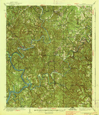
 1949 Sipsey1969 Print · USGSWalker County at the close of the 1940s reveals a landscape shaped by the winding Mulberry Fork and the arrival of industrial mining. Genealogists and historians can trace old schools and churches like Wheeler Sch and New Canaan Ch or locate family sites at Drummond Cem.5 unique versions available
 - 1951 Map of Sipsey
 1951 Sipsey1951 Print · USGSMid-century Walker County is shown here as a landscape of coal mining and river meanders just as the local industry peaked. Genealogists can trace family names at Rices Chapel, Maudlin Cem, and the rail junction at Sipsey.2 unique versions available
 - 1953 Map of Birmingham, 1964 Print
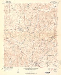
 1953 Birmingham1964 Print · USGSCentral Alabama at mid-century shows a landscape defined by industrial expansion and the iron-rich ridges surrounding Birmingham. Researchers can trace the extensive rail networks of the L & N RR or locate historic federal sites like the Anniston Ordnance Depot.4 unique versions available
 - 1956 Map of Birmingham
 1956 Birmingham1956 Print · USGSCentral Alabama in the mid-fifties exhibits a landscape of growing cities and deep-rooted industrial corridors. Genealogists and historians can trace the development of suburban Mountain Brook or locate regional hubs like Sylacauga and Jasper.
 - 1957 Map of Birmingham
 1957 Birmingham1957 Print · USGSNorth-Central Alabama in the mid-fifties is an industrial powerhouse centered on the steel valleys and sprawling iron ridges. Genealogists and historians can trace the rail-linked growth of Birmingham and Tuscaloosa, or locate rural landmarks like Talladega College and the Anniston Ordnance Depot.
 - 1971 Map of Dora, 1973 Print
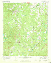 1971 Dora1973 Print · USGSThe river forks of the Alabama coal country come alive in the early seventies, showing a landscape defined by industry and community. Genealogists can trace family roots through Twilley Town, Quintown, and dozens of local landmarks like Morgan Chapel or the Walker Sch.5 unique versions available
 - 1975 Map of Dora, 1977 Print
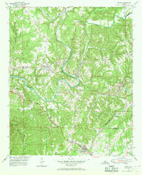
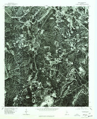 1975 Dora1977 Print · USGSWalker County and the surrounding coal districts are seen here in the mid-seventies through detailed aerial orthophotography. Researchers can trace the development of established towns like Dora, Sumiton, and the hillside layout of West Jefferson.
 - 1975 Map of Sipsey, 1977 Print
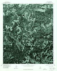 1975 Sipsey1977 Print · USGSThe Walker County landscape during the mid-seventies is captured here through detailed aerial imagery centered on the Sipsey River. Researchers can trace the layout of Sipsey and the northern reaches of Sumiton as they appeared decades ago.
 - 1984 Map of Jasper, 1985 Print
 1984 Jasper1985 Print · USGSIn the mid-1980s, the Walker County coalfields were a complex web of rail lines and river terminals. Researchers can trace the industrial heritage of the Mulberry Fork and locate local landmarks like the Carbon Hill National Fish Hatchery or Saragossa Ch.2 unique versions available
End of results
Showing maps 1-11 of 11
Top cities near Sumiton
- Birmingham historical maps
- Gardendale historical maps
- Jasper historical maps
- Forestdale historical maps
- Fultondale historical maps
- Pleasant Grove historical maps
See more
Top neighborhoods of Sumiton
Frequently asked questions
- What are the different types of historical maps available for Sumiton?
- What is the oldest map of Sumiton?
- Where can I purchase historical maps of Sumiton for my home or office?
- Where can I download high-res historical maps of Sumiton?
- Are there historical topographic maps available for Sumiton?
- Is there historical aerial imagery available for Sumiton?
- Where are historical maps of Sumiton sourced from?