1970s Maps of Sumiton, Alabama
Explore 3 historic maps of Sumiton from the 1970s. These maps offer a rare glimpse into what life looked like during the 1970s — showing old roads, neighborhoods, homes, and landmarks that have changed or disappeared over time.
Whether you're researching your family's past, planning a metal detecting trip, or studying how Sumiton's landscape evolved across the 1970s, these high-resolution maps are a powerful tool for exploring the history of this region.
- Focus on a specific era: All maps on this page are from the 1970s, giving you a focused view of this time period.
- See what’s changed: Compare century-old streets, trails, and buildings to today's modern landscape using overlays and satellite layers.
- Research with precision: Use these maps for genealogy, historical research, land use analysis, or educational projects.
- View, download, or print: Maps are fully viewable online in high resolution, and can be downloaded or printed for your own records.
Start exploring Sumiton's history through authentic maps from the 1970s. This is your window into the past.
Sumiton, AL maps
(3)- 1971 Map of Dora, 1973 Print
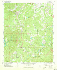 1971 Dora1973 Print · USGSThe river forks of the Alabama coal country come alive in the early seventies, showing a landscape defined by industry and community. Genealogists can trace family roots through Twilley Town, Quintown, and dozens of local landmarks like Morgan Chapel or the Walker Sch.5 unique versions available
 - 1975 Map of Dora, 1977 Print
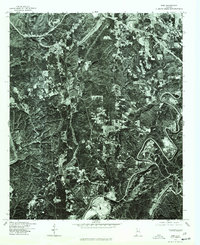 1975 Dora1977 Print · USGSWalker County and the surrounding coal districts are seen here in the mid-seventies through detailed aerial orthophotography. Researchers can trace the development of established towns like Dora, Sumiton, and the hillside layout of West Jefferson.
 - 1975 Map of Sipsey, 1977 Print
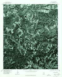 1975 Sipsey1977 Print · USGSThe Walker County landscape during the mid-seventies is captured here through detailed aerial imagery centered on the Sipsey River. Researchers can trace the layout of Sipsey and the northern reaches of Sumiton as they appeared decades ago.
End of results
Showing maps 1-3 of 3
Top cities near Sumiton
- Birmingham historical maps
- Gardendale historical maps
- Jasper historical maps
- Forestdale historical maps
- Fultondale historical maps
- Pleasant Grove historical maps
See more
Top neighborhoods of Sumiton
Frequently asked questions
- What are the different types of historical maps available for Sumiton?
- What is the oldest map of Sumiton?
- Where can I purchase historical maps of Sumiton for my home or office?
- Where can I download high-res historical maps of Sumiton?
- Are there historical topographic maps available for Sumiton?
- Is there historical aerial imagery available for Sumiton?
- Where are historical maps of Sumiton sourced from?